This forecast displays data for
both the
Jackson Hole Valley & the Teton Mountains. The
NWS National Blended Model (NBM) is utilized as the base,
MountainWeather™ then adds value to this by infusing over 30-years of local forecasting experience.
Jackson Hole Weather News
Some Jackson Hole weather history, records, and interesting weather facts…
- Mid-July has the warmest record high temperatures in Jackson, (101°F on July 17th & 20th, 1934), but the last week of July has the warmest average temperatures of the year in town, with an average high of 83°F and average low of 43°F.
- Record highs during the last week of July are: July 25th = 96°F in 2003. July 26th = 93°F in 1933. July 27th = 92°F in 1994. July 28th = 94°F in 1931. July 29th = 95°F in 1946. July 30th = 95°F in 2000. July 31st = 96°F in 2000.
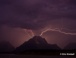
Click for the latest MountainWeather Blog: Lightning Safety >>
Click for Current Wildfires & Smoke Forecast Map >>
Quick-Look Today
Sunny then Chance T-storms
HI 91°F
Mountains @10,000ft
Today & Tonight
Today:
A 30 percent chance of showers and thunderstorms, mainly between 3pm and 4pm. Mostly sunny, with a high near 91. Light southwest wind becoming west southwest 5 to 10 mph in the afternoon. Winds could gust as high as 20 mph.
Tonight:
Increasing clouds, with a low around 57. West southwest wind 5 to 8 mph becoming calm in the evening.
Monday
Partly Sunny then Chance T-storms
TEMP @10,000ft
HI 66°F
LO 50°F
WIND SW
AVG 5 mph
GUST 12 mph
Day:
A 40 percent chance of showers and thunderstorms, mainly between 1pm and 5pm. Partly sunny, with a high near 89. Calm wind becoming west northwest around 6 mph in the afternoon.
Night:
Partly cloudy, with a low around 53. Northwest wind around 5 mph becoming calm in the evening.
More +
Tuesday
Sunny then Slight Chance T-storms
TEMP @10,000ft
HI 67°F
LO 46°F
WIND S
AVG 6 mph
GUST 12 mph
Day:
A 20 percent chance of showers and thunderstorms after noon. Mostly sunny, with a high near 90. Calm wind becoming west southwest around 6 mph in the afternoon.
Night:
A 10 percent chance of showers and thunderstorms before 9pm. Partly cloudy, with a low around 53. West southwest wind around 5 mph becoming calm in the evening.
More +
Wednesday
Slight Chance Showers then Chance T-storms
TEMP @10,000ft
HI 66°F
LO 46°F
WIND S
AVG 6 mph
GUST 13 mph
Day:
A slight chance of showers, then a chance of showers and thunderstorms after noon. Mostly sunny, with a high near 89. Calm wind becoming southwest 5 to 7 mph in the afternoon. Chance of precipitation is 30%.
Night:
A 10 percent chance of showers and thunderstorms before midnight. Partly cloudy, with a low around 52.
More +
Thursday
TEMP @10,000ft
HI 69°F
LO 44°F
WIND S
AVG 6 mph
GUST 15 mph
Day:
Sunny, with a high near 92.
Night:
Mostly clear, with a low around 53.
More +
5-Day Forecast Graphs
See Chart Description
See Chart Description
See Chart Description
Temperature Graph Description
This graph shows the temperature trend over the next 5 days (in degrees F.) Red Line is for Valley Temps, with daily highs plotted for each day on graph for a quicker read. Blue Line is for Mountain Temps at the 10,000-ft. elevation. Dashed line indicates the freezing point, 32F (0C).
Note: Hover over graph for more details.
This graph shows expected Wind Speeds (in mph) & Direction over the next 5 days, at around the 10,000-ft. elevation in the mountains. The lower Light Green Line represents Average Wind Speeds for the day. The upper Dark Green Line represents the maximum wind gust speeds expected. Average overall Wind Direction is labelled with an abbreviation, such as: W= West, SW= Southwest, NNW= North-Northwest, etc. This indicate the direction from which the wind is coming.
Thunderstorm Graph Description
This graph shows the probability of Thunderstorms around the Jackson Hole area & the Teton Mountains.
This graph represents the likelihood of Thunderstorms & dangerous Lightning occurring in the area, for both DAY & NITE. The bar scale represents LOW, MEDIUM or HIGH probability of Thunderstorms. DAY generally covers the time period between 6:00 AM & 6:00 PM. NITE is between 6:00 PM and 6:00 AM the following morning.
Snow Precipitation Graph Description
This graph shows the average expected snowfall amounts for the next 5 days in inches, broken down by DAY & NITE to give an idea of when the snow will be falling. Gray bars are for valley snowfall, Blue bars are for mountain snowfall at around the 9,000-ft. elevation in the Tetons. Number plotted is for a quicker read on mountain snow amounts.
Note: Snowfall amounts can vary widely from one location to another. In general, the Town of Jackson will get less snow than locations along the base of the mountains (Wilson, Teton Village & Moose). As you go further north into Grand Teton National Park (Moran, Colter Bay & South Gate of Yellowstone), expect much more snow than what is forecasted here. Mountain snowfall will vary widely by elevation & location, depending on favored flow directions & wind redistribution.
Click for a Printable Version of the JH Forecast >>
Click to read the Riverton NWS Forecast Discussion >>
Click to read the Pocatello NWS Forecast Discussion >>
JH Almanac Info
NWS Forecasts & Reports
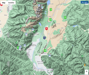
Jackson Hole WAM
 Weather Access Map for JH
How to Use this Map
- This map can be used to access Current Weather conditions AND Point Forecasts for each specific location.
- Current Weather observations are in 2 formats. …NWS & MesoWest.
- NWS Point Forecasts have 3 formats to choose from.
- Chose the NWS Graph button for the most detailed forecast info: hour by hour temps, winds, windchill, cloud cover, precip & snowfall amounts, and lightning activity forecasts.
- Use the Magnifying Glass icon to get a forecast for any location. It will stay in the center of the map as you move the map around. Zoom-in for a more precise location.
Click for Current Weather Conditions & Local Webcams >>
Click for Jackson Hole Lightning Map >>
Click for Local Avalanche Forecast >>