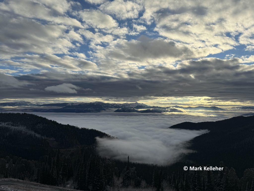
Jackson Hole just experienced one of its warmest and driest Novembers on record, with a persistent weather pattern throughout most of the month that left a Ridge of High pressure sitting over a good portion of the Western United States and the Northern Rockies. Few storm systems were able to penetrate this Ridge, the storms that did mainly swung southward from the Pacific, across the Southwestern U.S. and Northern Rockies.
The result for Jackson Hole was little snow and temperatures too warm to keep the snow-guns going to make much man-made snow. Not a good combination for a ski resort town. Fortunately, a good stream of moisture in a Northwesterly flow starting the first week of December helped get things back up closer to normal in the mountains, at least. Unfortunately, warmer temps again by the second week of December will negate the snow down low.
In this post I’ll review the temperature, snowfall, and precipitation numbers from this past November and compare them to the historic averages and records.
Record Warm Temperature
There are different metrics you can use to determine how warm or how cold a month was: 1) Average monthly high temperature, 2) Average monthly low temperature, 3) Mean monthly temperature, which is the average of the high and low for the month.
All data reported here comes from the official instruments at the Jackson Climate Station.
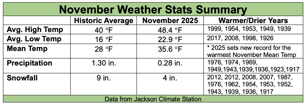
1) November 2025’s average high temperature for the month was 48.4 degrees Fahrenheit. That is 8 degrees warmer than the long-term average high in November of 40 degrees. The warmest day of the month was 64 degrees on November 3rd.
There have been five other Novembers with warmer average high temperatures than this past November’s 48.4 F: 1999 (51.6 F), 1954 (49.5 F), 1953 (48.5 F), 1949 (48.9 F), 1939 (50.8 F).
November 1999 had the warmest average high temperature on record (51.6 F). The coldest November on record was in 2022, just three years ago, with an average high for the month of 27.7 degrees.
2) November 2025’s average low temperature for the month was 22.9 degrees, or about 7 degrees warmer than the long-term average low in November of 16 degrees. The coldest day of the month was on November 25th, with a morning low temp of 5 degrees.
There were four other years when average low temperatures were as warm or warmer than this past November: 2017 (22.9 F), 2008 (23.8 F), and 1998 (24.8 F), 1926 (25.5 F).
That temp in 1926 qualified as the warmest average low temperature in the month of November. The coldest average low in November was in 1952, with an average low of 4 degrees for the month.
3) November 2025’s mean temperature was 35.6 F, which is about 8 degrees warmer than the long-term average, and qualifying as the warmest November mean temperature on record for the Town of Jackson. That broke the old record by a few tenths of a degree, from November 1953’s mean temp of 35.3 degrees. November 1949 is now in third place, with a monthly mean temperature in November of 35.2 degrees.
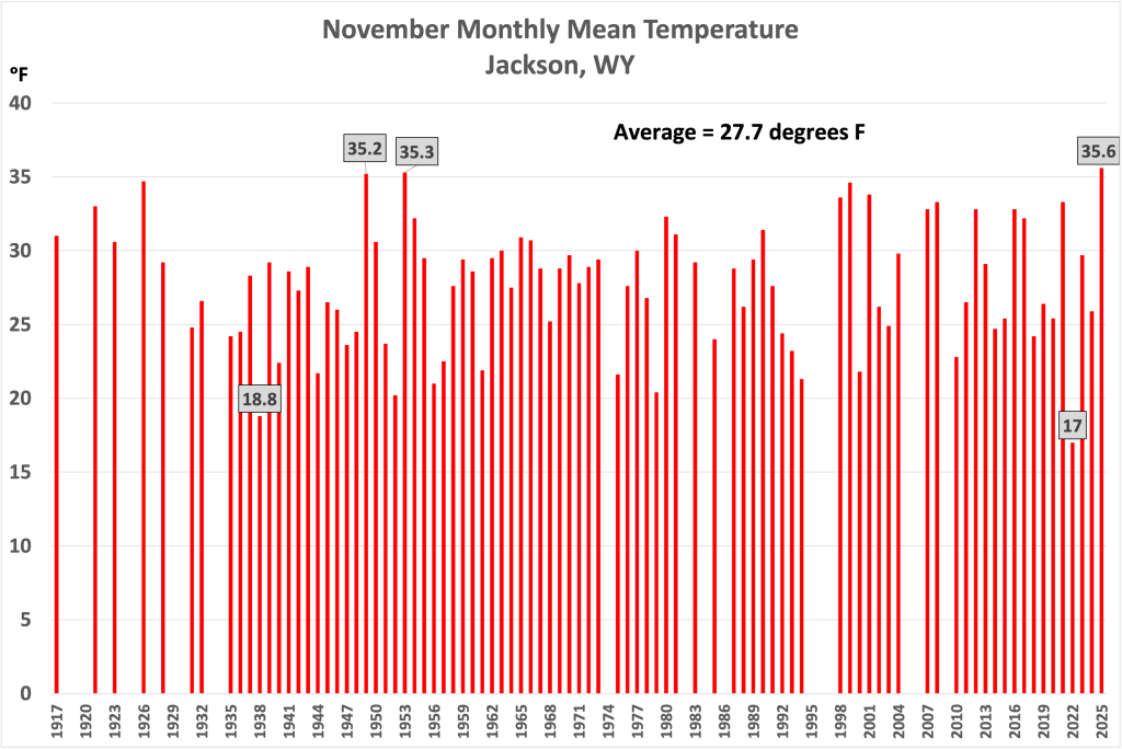
No other November with complete temperature records had as warm a combination of average high and low temperatures. What is even more amazing about breaking this warm temperature record is, just three years earlier in 2022 the coldest November mean temperature in Jackson was recorded. The mean temperature that November was 17.0 F, breaking the old record of 18.8 degrees from 1938, by nearly two degrees.
Low Snowfall & Precipitation
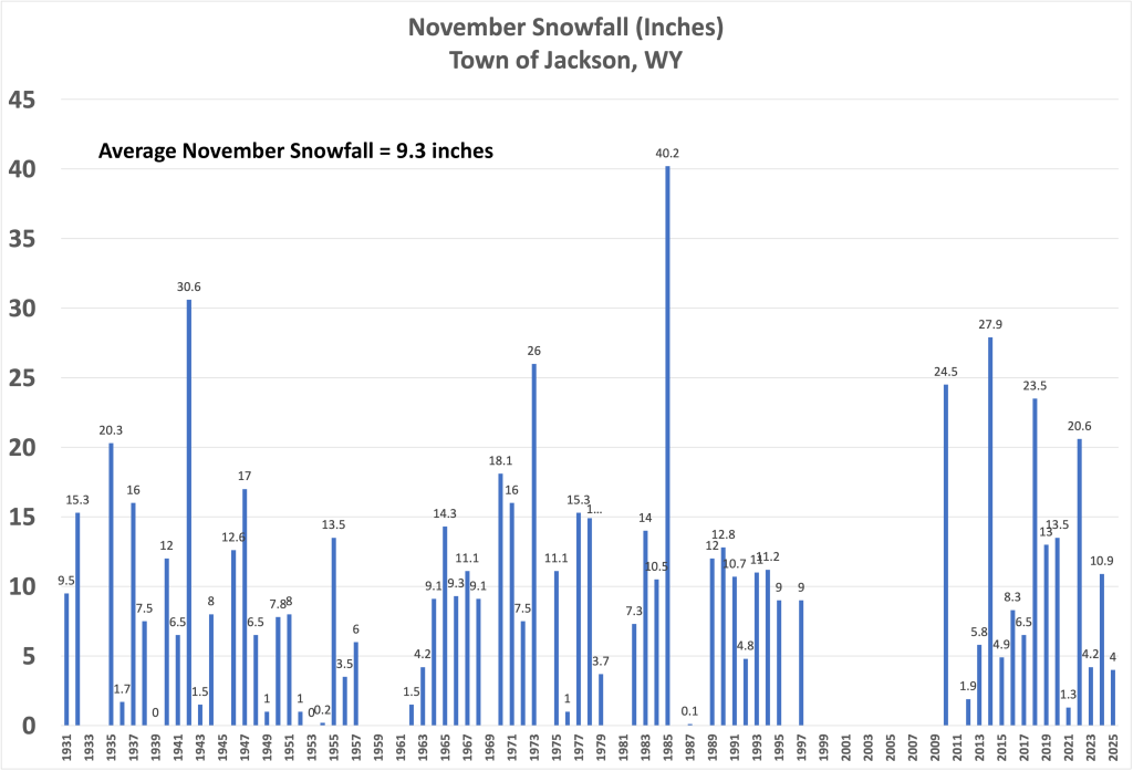
The Jackson Climate Station recorded 4 inches of snowfall for the month of November 2025. The historic average snowfall in November in town is 9 inches.
Four inches of snow in November might seem low because last November, in 2024, Jackson received almost 11 inches of snow. But the year before that, in November 2023, we only got 4.2 inches. And the year before that, in November 2022, we got 20.6 inches. But the year prior to that, in 2021, Jackson only had 1.3 inches of snowfall in November.
That is how up-and-down November snowfall can be from year to year. Looking back at the entire snowfall record for Jackson in November, for years with complete data, there were 14 other years with less snowfall in November than this one, going back to 1917. Two of those Novembers had absolutely no snow recorded in town in November: 1953, and 1939.
On the flip side, some of you may remember the snowiest November ever, that was in 1985 when 40 inches of snow fell in town that month.
Water content-wise, after well above average precipitation in October 2025, November 2025 ended up with a measly total of only 0.28 inches of precipitation in the Town of Jackson. The average precipitation in November is 1.30 inches.
This was not the driest November on record, but it was the driest we’ve seen here since 1976, when Jackson received only 0.10 inches that November. There were eight other years dating back to 1917 that were drier than this November: 1974, 1969, 1949, 1943, 1939, 1936, 1923, and 1917.
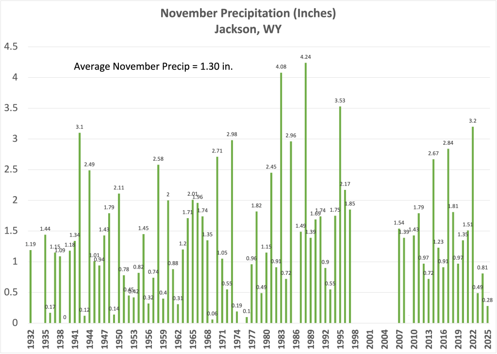
The driest November on record was in 1939, with no precipitation that entire month.
The wettest November on record was in 1988, with 4.24 inches of precipitation.
Post by meteorologist Jim Woodmencey