The real significance of Groundhog Day, on February 2nd every year, is that it marks the halfway point of the Winter Season. It is the midway point between the Winter Solstice (Dec. 21) and the Spring Equinox (Mar. 20).
Essentially, we have also reached the midway point of the ski season as well. The first half, December and January, may not have played out exactly as we had wished for, especially for snowfall in the valley. Yet some folks seem ready to write off the whole season already, thinking that a poor first half means we’ll have a bad second half. While others have implied that we’re doomed to have winters just like this, into the future.
Take for instance the headline on the front page of the February 4th, 2026 edition of the Jackson Hole News and Guide, proclaiming: “Snowpack portends climate future”. Certainly, an attention-grabbing headline that probably raised your snow-anxiety level another notch.
Within the article were some see-I-told-you-so statements from a pair of university professors, climate researchers apparently, who said, “This is all part of the trend”, and, “Extreme winters like this will become more regular”. Or, “What used to be extreme, is definitely much more normal now”. Quotes like that really tripped my meteorological trigger.
I would contend that Jackson’s winters have always been up and down, and it’s also the extremes of weather that make our averages. As a matter of fact, looking back over the last 50 winters, for just the first half of the winter season (December & January), the two biggest extremes at the Jackson Hole Mountain Resort were in 1976-77, the least snowy, and in 1996-97, which still boasts the record for the snowiest. We haven’t seen any winters that extreme since.
In the latest 25 years, Since 2020, snowfall on the upper mountain has been pretty consistent in December & January. Lower mountain snowfall has fallen below average the last few winters, but that data can be a bit deceiving, as that weather station has been moved to different locations a few times over the last 30 years.
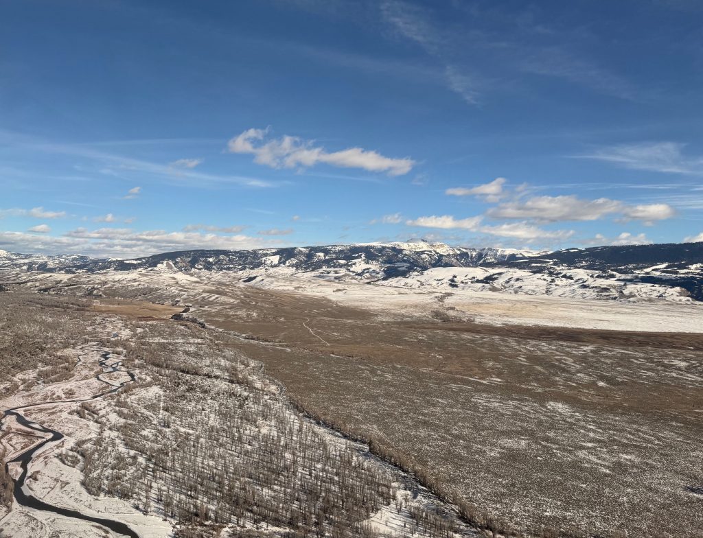
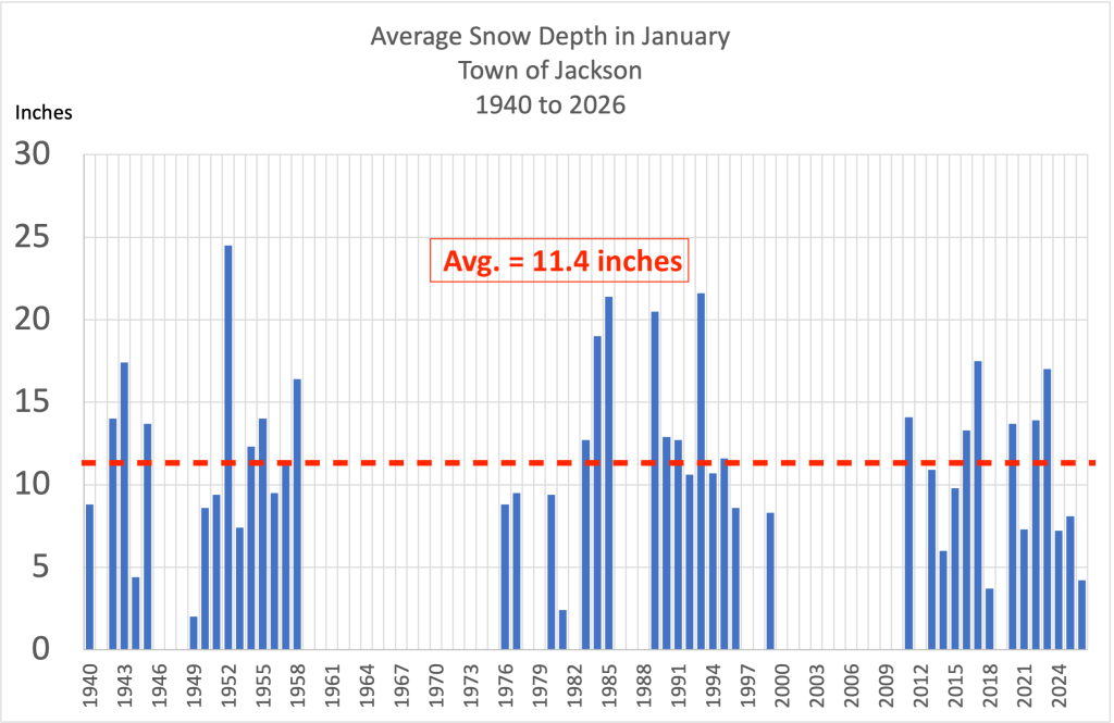
The only thing about this winter so far that could be considered extreme, is the snow depth at the base of the mountain at the end of January 2026, at only 8 inches, that is the shallowest we’ve seen in the last 50 years, on the 31st of January.
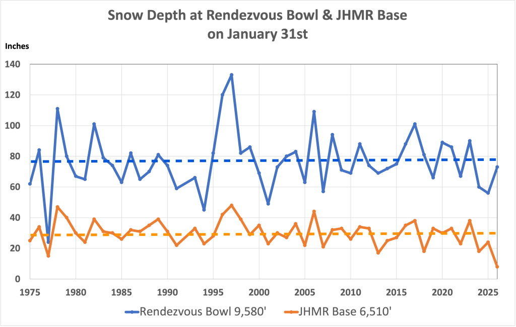
The graph below, shows how much snow depths have fluctuated on the upper mountain and at the base at JHMR over time on January 31st, for the last 50 years. That’s just for the first half of the ski season. You may recall the last two winters had slow starts to the first half, then it dumped in February and March.
To believe that the weather during one half of one winter season is proof a long-term trend is unscientific. So, don’t become a “panican” and sell your skis and winter clothes just yet. What we are looking at here is the weather, not climate.
Allow me to explain what caused the weather we had the last few months and then offer a better historical perspective on Jackson Hole’s snow history. Which will reveal similar or worse conditions here in the distant past.
Blocking pattern affected the first half of winter
So far this winter, across most of the Western United States, temperatures have been warmer than normal with below average snowfall amounts due to a persistent weather pattern that started back in November. A very strong Westerly jet stream across the Pacific has been splitting just off the West Coast as it encountered a very large and strong ridge of high pressure.
(You can also read about December’s weather here.)
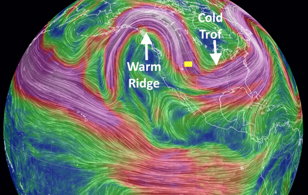
That ridge created a huge block in the atmosphere, preventing colder storms in the Gulf of Alaska from reaching the West Coast. Like plopping a huge boulder in the middle of the river, causing the water to flow around it.
The shifting position of the ridge determined the kind of weather we got in Jackson. When the ridge axis was positioned just east of us, a Southerly flow aloft was drawing warmer air up from far southern latitudes and moisture from tropical origins. That produced higher than average freezing levels and rain at lower elevations in December and early January.
When the ridge axis was west of us, we’d get a cooler Northerly flow, and dry weather. When the ridge was positioned directly over us, we’d also get dry weather, with temperature inversions, cold in the valley and warmer in the mountains.
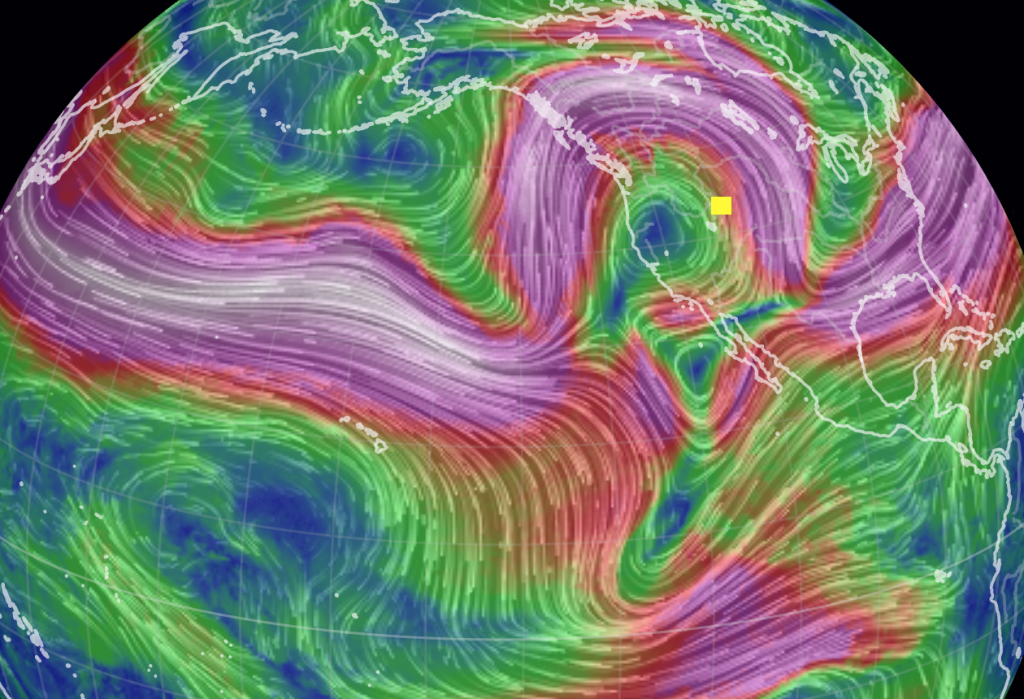
At the same time the West was stuck under this ridge, the Eastern United States was enduring an equally large trough of low pressure. That weather pattern produced record breaking cold and snow from the Midwest to the Atlantic Coast. Does that also portend that winters in the East will be like that more regularly? Perhaps we should pack up and move to Vermont next winter.
Snowpack in perspective
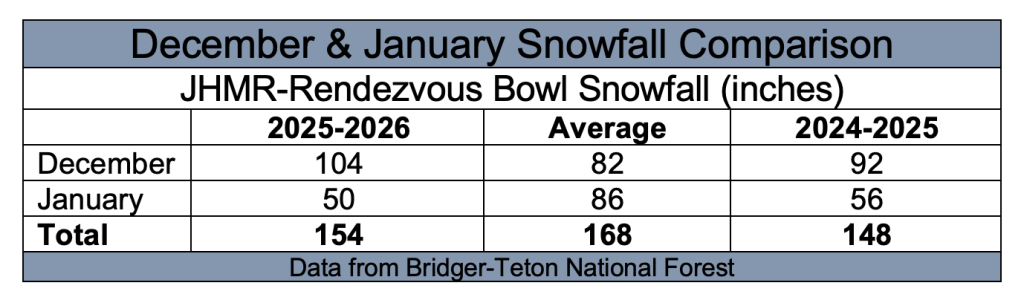
As mentioned, the snowpack at higher elevations in the Tetons did fine the first two months of winter this season. At the Rendezvous Bowl weather station, at around the 9,600-ft. elevation, the settled snow depth at the end of January 2026 was 73 inches. Just shy of the average for the last 50 years at that location of 77 inches, and well ahead of last season when it was only at 56 inches deep in the bowl on January 31st, 2025.
It’s the base of the mountain, at the around 6,500-ft. elevation, that was really lacking, with only an 8-inch snow depth on January 31st, 2026, the lowest on record for that date. Last year at the end of January 2025, it was at 24 inches. The historic average snow depth at the base of JHMR on January 31st is 30 inches. The lowest prior to that was in January 1977, with 15 inches on the ground.
The winter of 1976-77 was the worst (i.e. the most extreme) in the history of the JH Mountain Resort. On the upper mountain the snow depth at Rendezvous Bowl on January 31st, 1977, was only 24 inches, the lowest on record for that date.
According to friends who were here that winter, the area didn’t open until January 15th, and the lower mountain was unskiable. This was before they had any snow making. You had to ride the tram up, and the Thunder lift was operating, but you had to download from Tower-3 on the tram to get back to the base. The second half of winter was no better, and the mountain closed by March 15th, 1977.
If that was your first winter in Jackson, you’d be crying more than you are this year. If you hung out for the following winter, the mountain was having a historic first half of winter. By January 31st, 1978, the upper mountain and the base of the mountain saw what would become its second deepest snowpack on record. Second only to January 31st, 1997’s 133-inch snow depth.
( Valentine’s Day update: On February 14th, 2026 the snow depth at Rendezvous Bowl was at 84 inches. The historic average on that date is 85 inches. The Base snow depth is now up to 15 inches of settled snow, still about half of average, but better than the lowest year, in 2018 the snow was only 10 inches deep at the base.)
Town Snow Depth
At the Town of Jackson Climate Station, the average settled snow depth on the ground during the whole month of January 2026 was 4.2 inches. That’s well short of the long-term average snow depth in January of 11.6 inches.
(Note: That number is calculated using only years when there were no more than 5 missing days of data in the month, to get a more accurate gauge of monthly average snow depth).
There were years that had less snow on the ground during the month of January. In 2018 the average snow depth in town for the month was 3.7 inches. In 1981 it was 2.4 inches. In 1949 it was 2 inches.
There were also plenty of years recently that had deeper average snow depths in January, including: 2023, 2022, 2020, 2019, 2017, and 2016.
Another way to look at it is by comparing the average snow depth on January 31st in town, in 2026 it was at 4 inches on the 31st. There were three other years for which there are records that had less snow on the ground on that date: 2018 = 1 inch. 2003 = 1 inch. 1931 = 3 inches.
January 2025 Jackson had 9 inches on the ground. The historic average snow depth on January 31st is 14.5 inches.
Town Snowfall
Jackson also recorded 9.1 inches of total snowfall in January 2026, most of which fell in the first 8 days of the month. That total was about half of the long-term average snowfall in January of 18.5 inches. But, it was more than twice as much snow as we received last year, January 2025 only had 4.2 inches of total snowfall for the month.
Looking back at January snowfall totals in town for the five years previous to that, from 2020 to 2024, only one of those was below average. Here is the list: January 2020 had 35.6 inches. January 2021 had 24.1 inches. January 2022 had 15.1 inches. January 2023 had 19.8 inches. January 2024 had 21.9 inches. I guess I fail to see any trend towards extremes here.
Analyzing the available data for monthly snowfall in January, with years that had complete records, there were 18 other January’s in Jackson’s historical record that had less snow than January 2026, dating back to 1931, which only had 3 inches of snowfall in town. January 1962 only 2 inches of snowfall that January in town, and 1992 had the least, with just 1.6 inches of snowfall.
The extremes on the high end happened in the 1960’s, with 56 inches of snowfall in January 1969 and 48 inches in 1967.
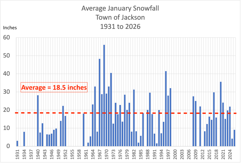
Again, using the criteria of only using months with no more than 5 missing days. Which oddly has fewer missing years than the snow depth chart. I suppose some years the daily snowfall was measured, but snow depth was not recorded every day.
Town Water
The Town of Jackson received 1.14 inches of water in January 2026, not radically below the average for January of 1.43 inches. Again, that was better than last year, in January 2025 Jackson only had 0.36 inches of precipitation.
It may seem counter-intuitive, but between 2020 and 2024, when Jackson had those above average snowfalls in January, only 2020 had above average precipitation. That’s because when temperatures are colder, you can yield more inches of snow out of the same amount of water. Which kind of blows the theory that we’re seeing more rain down at low elevations in recent years. This December and early January was certainly the exception, rather than the rule.
Jackson’s total water mount for December 2025 and January 2026 was 4.72 inches. Historic average total precipitation those two months is 2.95 inches. Well above the average, so you can’t call it a dry winter, so far.
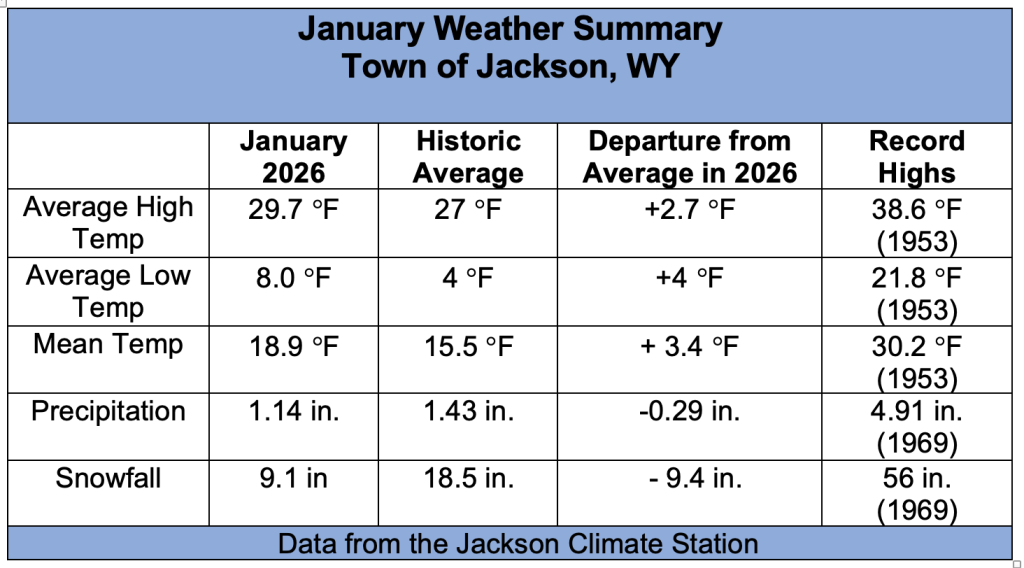
January Town Temps
The average high temperature in the Town of Jackson in January 2026 was 29.7 degrees, which is almost 3 degrees warmer than the long-term average of 27 degrees. The average low temperature in January 2026 was 8 degrees, or 4 degrees warmer than the long-term average low for January of 4 degrees.
Last year in January 2025, the average high was 22.6 degrees, or more than 4 degrees colder than normal. And the average low was minus 2.3 degrees, or more than 6 degrees colder than normal. One up, one down.
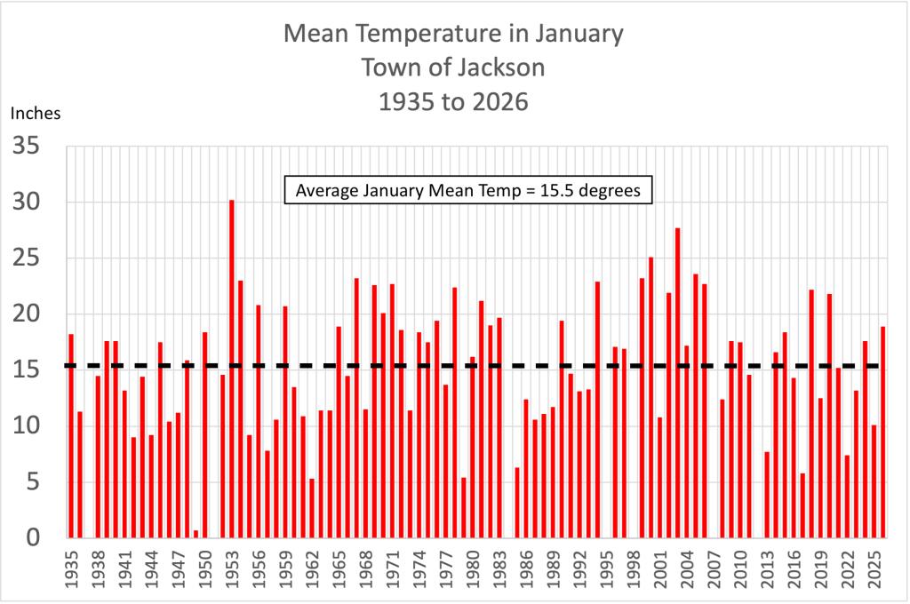
The mean temperature this January was 18.9 degrees, the average if the average high and low temperature for the month. The historic average mean temperature in January is 15.5 degrees. So overall Jackson was 3.4 degrees warmer than normal.
January 2025, was more than 5 degrees colder than normal, with a mean monthly temperature last January of 10.1 degrees. One colder January, followed by one warmer January. Do you see the trend? ….Sorry, I’m being sarcastic.
Consistent records of average mean temperatures go back to around 1935, before that the record is more sporadic. The chart below shows Average Mean Temperatures in Jackson for the last 91 years.
In case you weren’t here to experience all of our fluctuations in temperature the last 90 years prior to this one, here are a few highlights:
— In the last 14 years, since January 2013, there have been 6 Januarys with above average mean temperatures and 8 January with below average mean temps in Jackson.
— The warmest, most extreme, January on record was in 1953, with a mean temperature of 30.2 degrees .
— The coldest, most extreme, January was 4 years prior to that, in 1949, with a mean monthly temperature that January of only 0.7 degrees!
January Summary & Comparison
Closing Thoughts
It’s funny to me how a couple of abnormal winter months are suddenly branded as the “new normal”. What about all those recent years with above normal snowfall, were they not establishing the “new normal” too? What about the years that were warmer or colder than this January? And if we are expecting the weather to become more extreme, will it be more extreme that it was in previous decades, like in the 1930’s, 40’s, 50’s, 60’s, 70’s, 80’s or 90’s?
Our memories of the weather are pretty short. And I have to admit, in the last 15 years or so Jackson has been blessed with some pretty awesome winters, if you gauge winter by snowfall amounts and the quality of the powder skiing. Sub-par conditions seem to have become unacceptable, or at least unrecognizable, based on your mind’s limited data set.
I’ve been fortunate enough to have lived in Jackson for most of the last five decades, and each winter was somewhat different than the one before. Part of my job the last 35 years has been tracking and analyzing Jackson’s weather, and as you can see from these records, there has always been a lot of variability. I can also tell you, some of the biggest swings in the weather occur in the months of December and January. And that is because of the variability of the weather patterns that set up across the Pacific.
My point in all this analysis is that almost every winter in Jackson is different. One unusual winter, or part of a winter, doesn’t define a “new normal” or portend anything into the future. So, expect the ups and downs and the extremes of weather to continue, as they have in the past and certainly will into our climate future.
Post by meteorologist Jim Woodmencey, who has lived in Jackson for 44 years and has forecast and tracked the weather here for 35 years.