This forecast displays data for both the Jackson Hole Valley & the Teton Mountains. The NWS National Blended Model (NBM) is utilized as the base, MountainWeather™ then adds value to this by infusing over 30-years of local forecasting experience.
Jackson Hole Weather News
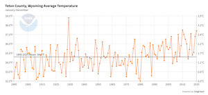
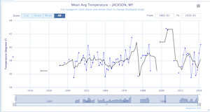
Some Jackson Hole weather history, records, and interesting weather facts…
- The Summer Solstice this year will occur early on Sunday morning, June 21st, 2026, at 2:24 am MDT.
- On Sunday the official sunrise is at 5:42 am in Jackson and sunset is at 9:07 pm, providing 15 hours & 25 minutes of daylight.
- Add to that 36 minutes of twilight in the morning and 36 minutes of twilight in the evening, providing us with the longest day of the year in the Northern Hemisphere.
Click for the latest MountainWeather Blog: Summer 2026 Outlook >>

National Digital Forecast Database
Jackson Hole and Teton Mountain Range
Forecast Powered by MountainWeather™ & NWS
Issued on:
Saturday, June 27, 2026

Severe Thunderstorms and Breezy
Mountains @10,000ft
TEMP
WIND SW
Today:
Tonight:

Isolated showers and thunderstorms after noon. Partly sunny, with a high near 59. West southwest wind 9 to 13 mph, with gusts as high as 20 mph. Chance of precipitation is 20%.
A chance of rain showers before 3am, then a chance of rain and snow showers. Some thunder is also possible. Partly cloudy, with a low around 31. South southwest wind 7 to 11 mph, with gusts as high as 20 mph. Chance of precipitation is 40%. Little or no snow accumulation expected.

Rain likely, possibly mixed with snow showers before noon, then a chance of rain showers. Some thunder is also possible. Mostly cloudy, with a high near 59. Breezy, with a south southwest wind 9 to 15 mph, with gusts as high as 22 mph. Chance of precipitation is 60%. Little or no snow accumulation expected.
A slight chance of showers and thunderstorms before 9pm, then a slight chance of showers between 9pm and midnight. Mostly cloudy, with a low around 34. West southwest wind 5 to 10 mph becoming light and variable in the evening. Winds could gust as high as 20 mph. Chance of precipitation is 20%.

A 20 percent chance of showers and thunderstorms after noon. Mostly sunny, with a high near 68. Calm wind becoming west southwest 5 to 9 mph in the morning.
Partly cloudy, with a low around 36.
A 20 percent chance of showers and thunderstorms after noon. Mostly sunny, with a high near 73.
Partly cloudy, with a low around 40.
5-Day Forecast Graphs
Click for a Printable Version of the JH Forecast >>
Click to read the Riverton NWS Forecast Discussion >>
Click to read the Pocatello NWS Forecast Discussion >>
JH Almanac Info
Today
Sunset: 9:06pm
Sunset: 9:06pm
Sunset: 9:05pm
Sunset: 9:05pm
Sunset: 9:05pm
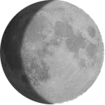
Waxing Gibbous
Current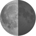
Last Qtr.
Jul 7th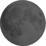
New Moon
Jul 14th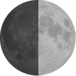
First Qtr.
Jul 21stThis Week’s...
Average Hi: 76°F
on June 25, 1953
on June 26, 1988
NWS Forecasts & Reports
Jackson Hole WAM
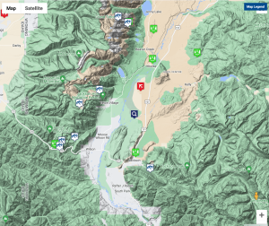
How to Use this Map
- This map can be used to access Current Weather conditions AND Point Forecasts for each specific location.
- Current Weather observations are in 2 formats. …NWS & MesoWest.
- NWS Point Forecasts have 3 formats to choose from.
- Chose the NWS Graph button for the most detailed forecast info: hour by hour temps, winds, windchill, cloud cover, precip & snowfall amounts, and lightning activity forecasts.
- Use the Magnifying Glass icon to get a forecast for any location. It will stay in the center of the map as you move the map around. Zoom-in for a more precise location.
NWS Forecast Links
![]()
JH Tram @10,000-ft.
Tetons @11,600-ft.
Discussions
Local JH Reports
Other Reports
Ski Reports
Click for Current Weather Conditions & Local Webcams >>