All we have heard so far this spring is that we are in for a hot, dry, summer with a busy wildfire season expected over the next few months. As I look back at the last 20 years or so, that has pretty much been the outlook almost every summer here in Northwest Wyoming.
Will this summer somehow be uniquely different? Let’s look at the current outlooks for June, July, and August 2026 and break down what they might portend. Then look back at a similar historical situation to see how that panned out.
NOAA’s Outlook
The most recent Three-Month Outlook issued by NOAA on May 21, 2026, for this June, July, and August, shows Northwestern Wyoming is in the “Likely” category for above normal temperatures. The probability of that happening is listed at 50 to 60 percent. (Refer to the Outlook graphics included here).
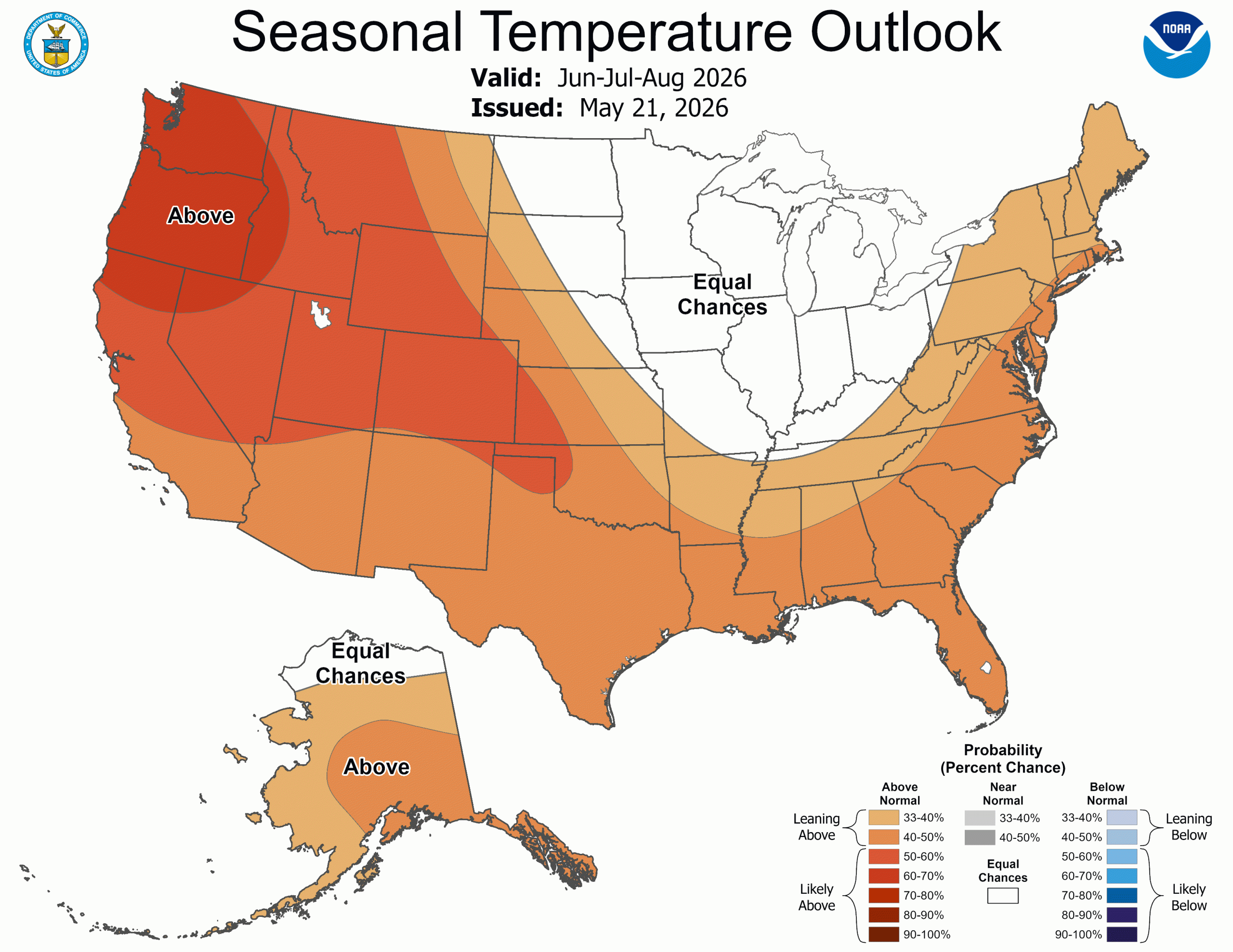
Northwest Wyoming falls under the “Equal Chances” category for precipitation this summer. That does not mean we’ll have a “normal” amount of precipitation, as some people may perceive it. What it means is, there are equal chances of having above normal precipitation, below normal precipitation, or average precipitation. The probability of each one of those occurring is 33.3 percent.
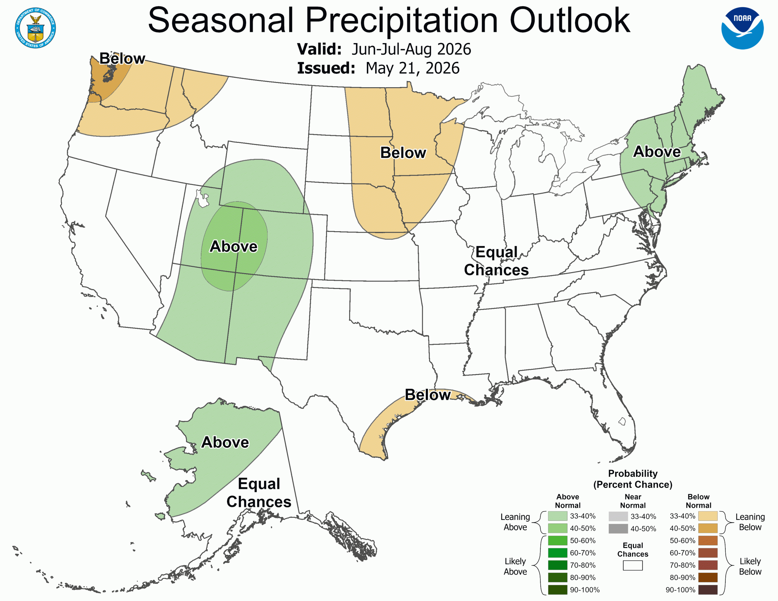
To make it into either the above normal or below normal category, the probability of occurrence needs to be more than 33 percent. Southwest, Central, and Southeast Wyoming are leaning towards the above normal category for precipitation, with a 33 to 40 percent chance of precipitation being above normal this summer.
You could interpret this summer’s outlook from NOAA to mean that the weather, overall, for the next three months here in Jackson Hole will be warmer than normal. How much precipitation we might get is still a coin toss. But you’ll need a three-sided coin to decide the precipitation outlook.
How to read the Outlooks
Making these Three-Month Seasonal Outlooks involves a rather complicated methodology that NOAA uses to arrive at these probabilities. Here is the explanation from the Climate Prediction Center’s website:
“The contours on the map show the total probability (%) of three categories, above, indicated by the letter “A”, below, indicated by the letter “B”, and the middle category, indicated by the letter “N”. At any point on the map, the sum of the probabilities of these three categories is 100%.
For any particular location, and season, these three categories are defined from the 30 observations from 1981-2010. The coldest or driest 1/3 (10 years) define the B category, the warmest or wettest 1/3 (10 years) define the A category, and the remaining 10 years in between define the middle (N) category.
When the forecasters decide that one of the extreme categories, say above (A), is the most likely one, they assign probabilities which exceed 33.33% to that category, and label the map with an “A” in the center of the region of enhanced probabilities. To make it possible to display three categories on one map, we assume that, when either A, or B is the most likely category, the probability of the middle category remains at 33.33% for most situations. This means, for example, that when the probability of A (B) is 40%, the probability of N is 33.33%, and the probability of B (A) is 100% minus 40%+33.33%=26.67%.
When probability values of the favored category reaches 70%, or higher, the probability of the opposite category is fixed at 3.3%, and the probability of the middle category is adjusted to values (less than 33.33%) which cause the sum of the three probabilities to equal 100%.
When the middle category (N) is higher than 33.33%, the probabilities of the A and B categories decline by (equal) amounts required for the sum of the A, N, B probabilities to equal 100%.
In regions where the forecasters have no forecast tools which favor the chance of either A, or B, the chance of these two categories is defined to be 33.33% each, and the region is labeled “EC”, which stands for equal chances.
Shading is used to indicate different levels of probability above 33.33%.”
Compared with the Summer 2022
The last time we were in a similar situation most recently, with a low snowfall winter preceding the coming summer, was in 2022. The winter of 2021-22 had below normal snowfall in the mountains for December through March with only 241 inches, which was even less than this past winter’s 252 inches.
Town had a total of 54 inches of snowfall for December through March 2021-22, compared to 45 inches this past winter. However, the Winter of 2021-22 only had a total of 4.01 inches of precipitation with that snow, compared to 7.11 inches of precipitation in town from December through March 2025-26. The average winter precipitation in the Town of Jackson is 5.48 inches.
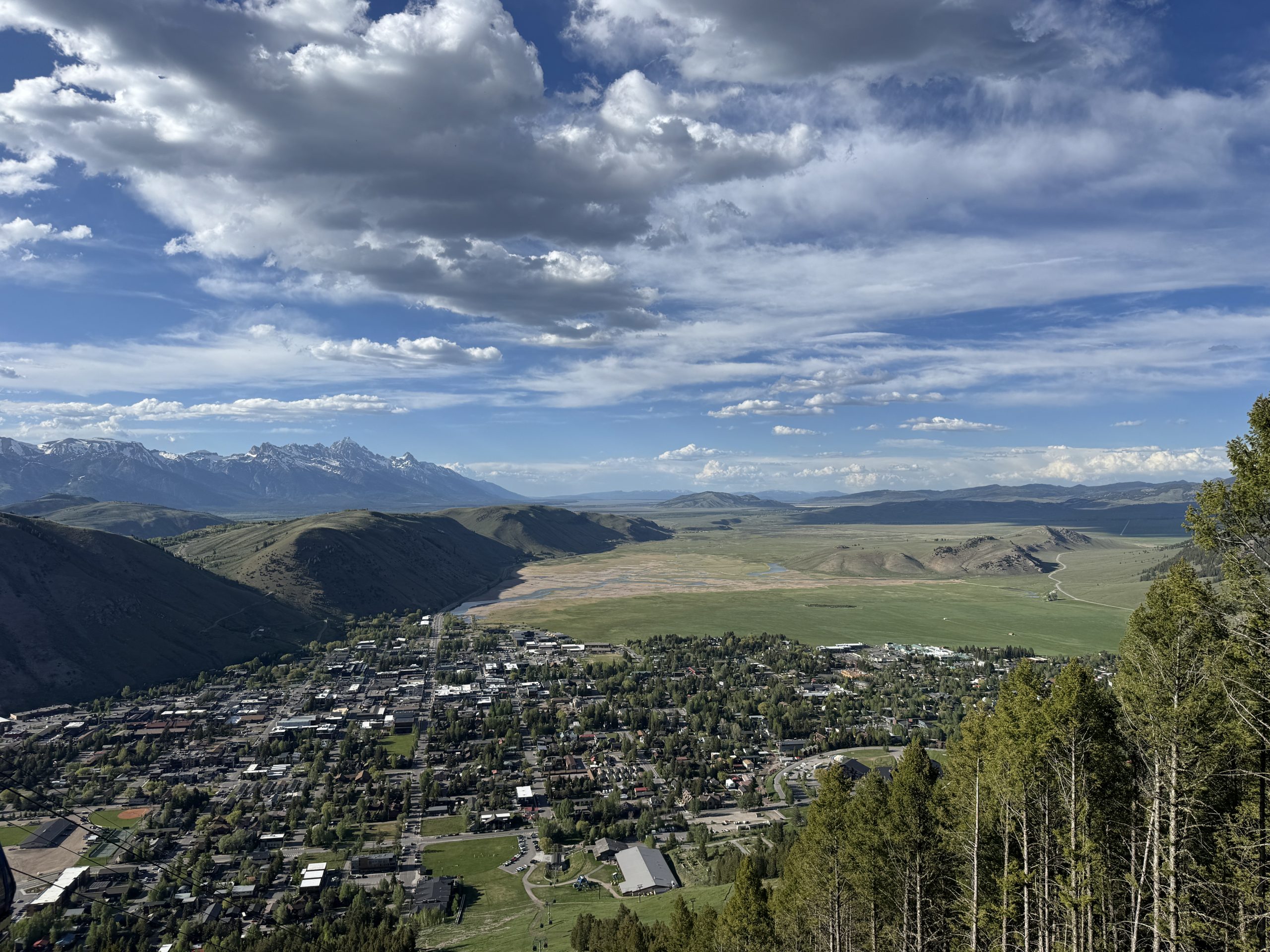
Add to that above average precipitation for April through May, another 3.48 inches combined, bringing the total precipitation for October 2025 through May 2026 up to 10.51 inches. That is 2 inches above the long term average of 8.52 inches for those 8 months. Maybe that is why the valley looks so green right now.
April and May of 2022 also had above average precipitation here in Jackson, leading into the summer months. So, what was the outlook for that coming Summer of 2022? You guessed it, “warmer and drier than normal” for Northwest Wyoming.
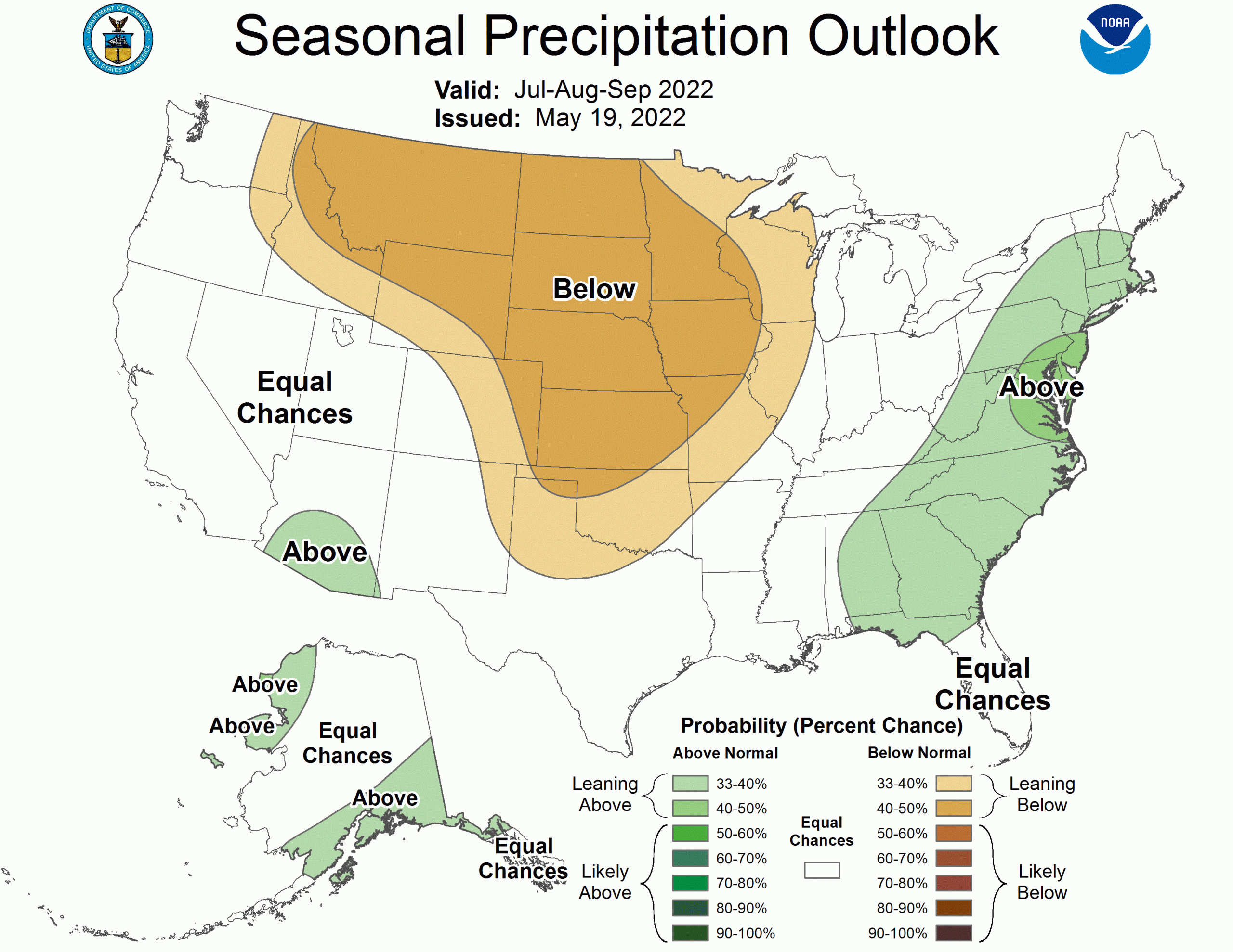
Here are the outlook maps from NOAA, from May 19th, 2022:
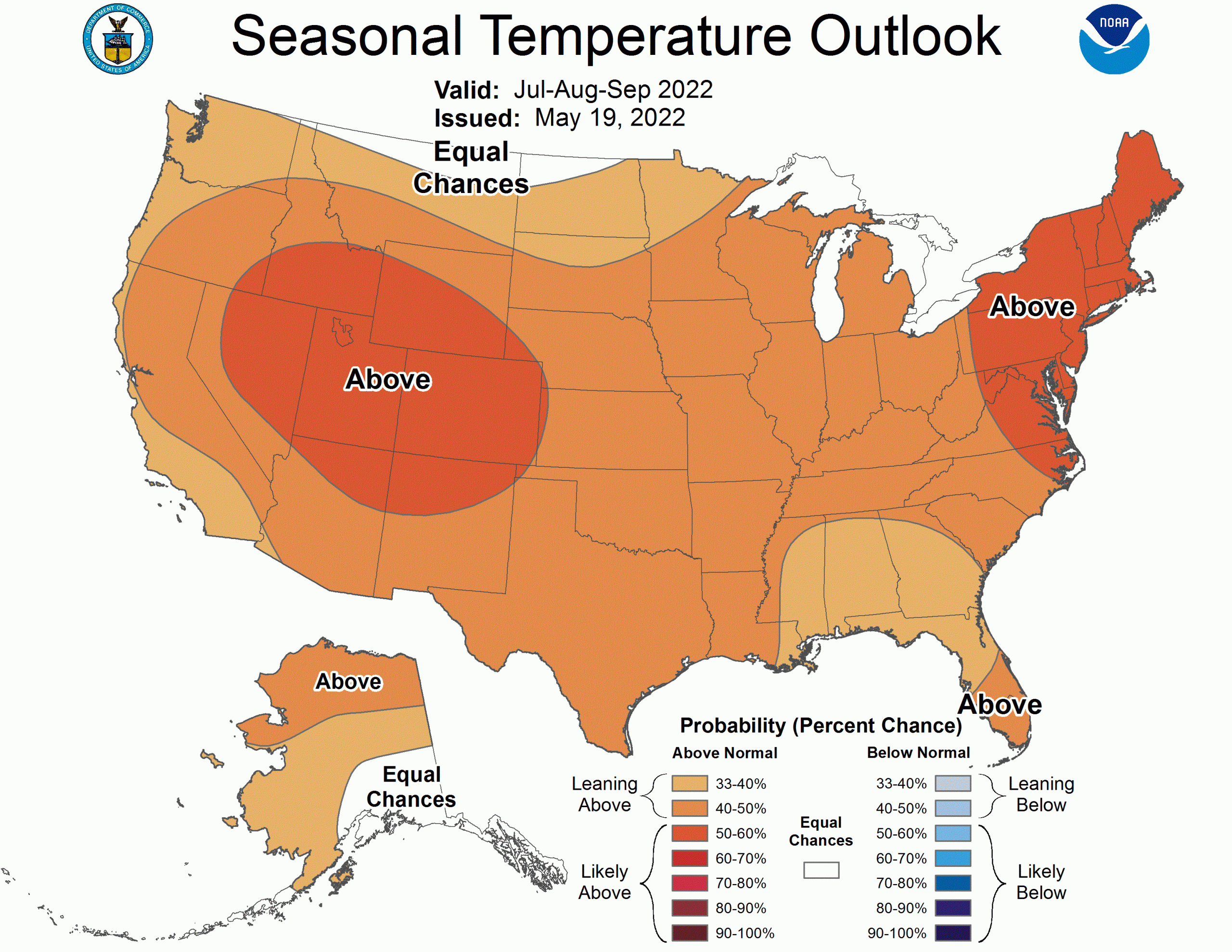
The NOAA Outlook for Summer 2022 had Northwestern Wyoming solidly in the “likely” to be above normal category for temperatures, in the 50 to 60 percent range. And for precipitation, it was forecast as “likely” to be below normal, in the 40 to 50 percent chance range.
What really happened in the Summer of 2022? Monthly average high temperatures were colder than normal for the summer. Average low temperatures were warmer than normal. Overall, the mean temperature for the summer was right at average. Not above average, nor below.
June 2022’s precipitation was near normal, July was way below normal, but August 2022 was well above normal due to a more active monsoon, creating the second wettest August in the Town of Jackson’s weather history. Jackson ended up with 5.26 inches of rain in June, July and August of 2022. That is 140 percent of the normal summer precipitation of 3.77 inches.
Sorry to say, but that summer’s outlook was a bust. That’s only one example, and I’m not saying this summer’s outlook will be a bust also. We’ll just have to wait until September to judge that.
To “Summerize”
How this summer plays out will depend on the weather patterns that develop, especially how strong the Desert Southwest Monsoon becomes later in July and August. And whether that monsoon moisture surges this far north often enough to bring significant precipitation, like it did in 2022.
With the monsoon, as with more typical summer thunderstorms, comes lightning. That will also be a factor in what kind of wildfire season we have. But keep in mind, only about 20 percent of wildfires in the United States are caused by lightning, the other 80 percent are human caused.
We can do our part in reducing the threat of wildfires by making sure your campfires this summer are dead out before you leave them unattended. Maybe even chose to forego the campfire in particularly dry places or at least be cognizant of sparks getting away from you when it is too windy.
No matter what the weather, get out and enjoy this summer, because they are typically pretty darn short here in Wyoming.
Jim is the chief meteorologist at mountainweather.com and has forecast the weather in Jackson Hole for the last 35 years.
Portions of this post appeared in the June 3rd, 2026 issue of the Jackson Hole News & Guide