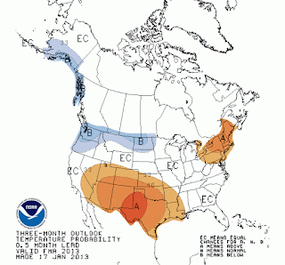
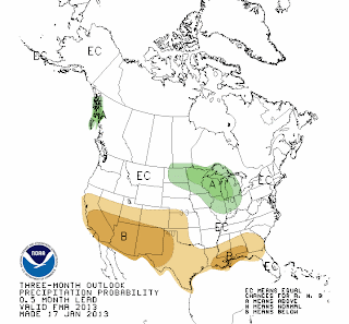
The Climate Prediction Center or “CPC” (a division of NOAA and the National Weather Service) is responsible for producing our long-range outlooks. For the next three months they are showing that the Pacific Northwest will be about the only place in the USA that has a good probability of experiencing below normal temps. Nowhere in the western US is expected to see above normal precipitation. The Southwestern US has a higher probability of seeing below normal precipitation February thru April.
Alaska, the Pacific Northwest, Idaho, Montana, and Wyoming will be sitting basically in a climatalogical no-man’s land during February thru April, as far as our chances of precipitation go.
The CPC determined that this part of the country will have “Equal Chances” of being above normal, below normal, or normal, in the precipitation category.
That pretty much covers it!
So, I could interpret that to mean we’ll either get dumped on, or not not get dumped on, or have something in-between. A very helpful bit of insight. Not.
(See more maps and follow the latest short & long range outlooks on the Long-Range Outlooks Page of mountainweather.com)
|
3-Month Outlook Maps for February-March-April 2013
|
|
|
|
|
Temperatures
|
Precipitation
|
El Nino-La Nina-No Nino
While we began the Winter of 2012-13 with a weak El Nino condition in the Equatorial Pacific (that is, slightly warmer than normal sea-surface temperatures off the coast of Peru), indications are that we are transitioning to more of a “Neutral” condition in the Equatorial Pacific as we head towards the Spring Season. What I will call a “No-Nino” situation.
What does that mean for us? Basically,nothing. As you can see from the 3-month outlooks above, the long range forecasters are calling it an even bet on both precipitation & temps for the northern Rockies at least, including Jackson Hole.
You might interpret all of this to mean that we will have a “normal” second half of winter and start to the spring season. If there is such a thing as normal weather in Jackson Hole!
Text submitted by meteorologist Jim Woodmencey
Graphics from NOAA


