(This article originally appeared in the Jackson Hole News & Guide on Oct. 26, 2016)
At the very end of August, in this column, I gave you the early, early winter outlook for 2016-17. That was ridiculously early to be talking about winter. Now that we are deep into October, have some snow on the ground, and some among us have already been skiing, I thought it might be a good time to update what was said back in August.
Some predictions will not change, like the Farmer’s Almanacs, but an update from NOAA and the El Nino/La Nina situation might provide better insight, as we get closer to the actual winter months.
The Outlooks
As you may recall from that August column, the two most prominent Farmer’s Almanacs were basically at odds with each other, as to what sort of winter this part of the country would have. One painted a picture of “Mild and Dry” conditions across the State of Wyoming, the other depicted “Freezing Cold with Average Snowfall” for this part of the country. That was neither helpful nor definitive.
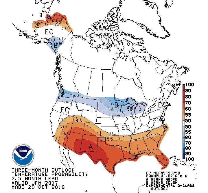
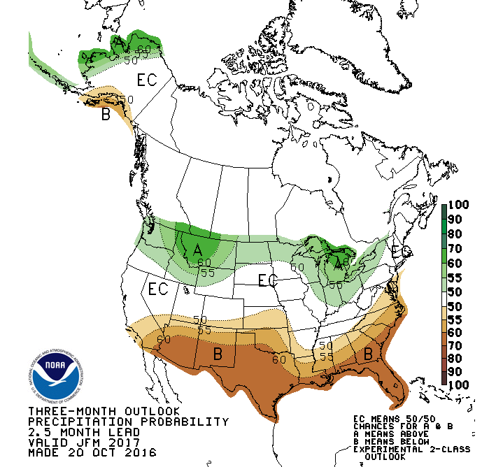
Back in August of this year, the Climate Prediction Center (CPC), which produces three-month outlooks of temperatures and precipitation, was telling a slightly different story than the Almanacs. The CPC had us right on the line for a 50/50 chance of being warmer than normal in December-January-February. For precipitation, Northwest Wyoming looked to have a slightly better than a 50-percent chance of having above normal precipitation this winter.
The latest predictions from the CPC, made at the end of last week, show that we now have a little better than a 50-percent chance of being warmer than normal, and are closer to a 55-percent chance of having above normal precipitation, in the December-January-February time period.
If you look at the next three-month prediction, for January-February-March of 2017, then we drop into the “Equal Chances” category for temperatures; that is, it could be above or below normal, temperature-wise, for these three months. For precipitation, Northwest Wyoming hangs closer to that 55-percent chance of above normal precipitation.


Trend-wise, I would say that might result in something closer to normal temperature-wise for Jackson Hole this winter, and our odds of having above normal snowfall this winter in Jackson Hole are solidly better than 50/50, through the winter months.
Now, let’s see how the projected La Nina situation is developing first.
El Nino/La Nina
To review: El Nino is one phase of what is known as the El Nino Southern Oscillation (ENSO), which is tied to the fluctuations in sea-surface temperatures in the Equatorial Pacific. During an El Nino, those water temperatures are warmer than normal. During a La Nina, they are cooler than normal.
El Nino winters generally bring warmer and drier conditions across the northern Rockies. Note: we had a strong El Nino last winter and yet we ended up with a winter that had average temperatures and just above normal snowfall.
La Nina winters typically bring and cooler and wetter weather to the Pacific Northwest and the northern tier of the United States. Like the strong La Nina winter we had in 2010-11.
At present, conditions in the Equatorial Pacific are near neutral or slightly cooler than normal. Therefore, water temps will have to start diving before they will call it a full-fledged La Nina. The prediction is that a weak La Nina will develop (70-percent chance) and may persist (55-percent chance) through the winter months.
For the latest updated info on La Nina, Click Here>>
If actually we end up with more of a “Neutral”, or No-Nino winter, then our odds of an above normal winter could drop. Part of what goes into those CPC forecasts depends on these ENSO predictions for the winter.
One last thing, which I personally like to look at, is what the water temperatures are doing in the northern Pacific. This is related to what is known as the Pacific Decadal Oscillation, or PDO. During the last two winters (2014-15 and 2015-16) the temperatures in that part of the Pacific have been warmer than normal, unusually warm at times.
Since June of 2016 those temps have been in a steady decline, and were almost back to normal by the end of September. My hypothesis is: whenever the PDO is near or cooler than normal, Jackson Hole has a bigger winter.
Let’s root for that northern Pacific Ocean to keep on cooling down over the next few months. That could make for a very “powder-full” winter here.
Jim is the chief meteorologist at mountainweather.com and has been forecasting the weather in Jackson Hole and the Teton Mountains for the last 25 years.

