Is there such a thing as a typical El Niño or La Niña?
Every year there is always a lot of talk about El Niño and La Niña and how it might affect the weather, especially our winter snowfall. The terms have become quite commonplace, although I suspect most people don’t fully understand what these terms mean. We just assume that whatever is going on with the weather is because, “It’s an El Nino year”, or “It’s a La Nina year”.
This winter started out warm and dry in Jackson. Blame that on El Niño, right? Then, it started snowing in mid-January, followed by the major dump of snow we just had mid-February. Do we also blame that on El Niño? Well, consider this, we now have a deeper snowpack in town and in the mountains than we had last year at this same time, when it was a La Niña year.
Let’s take a closer look at what defines an El Niño or a La Niña and what other things influence the weather we get from one winter to the next.
ENSO
El Niño and La Niña are part of what is known as the El Niño Southern Oscillation, or ENSO. There are three phases to ENSO that are based on the sea-surface temperatures in the Equatorial Pacific. El Nino is the warm phase, La Nina is the cold phase, and then there is a neutral phase, when sea surface temps are closer to normal, I’ll call that a No Niño. These conditions develop over a period of months and may last from 3 to 12 months, or longer.
ENSO conditions go back & forth between warmer and colder every few years. Some events are stronger, although the majority are weaker events.
Stronger events tend to have more of an impact on the weather patterns across the Northern Pacific Ocean during the winter months and are often loosely correlated with areas of above & below normal snowfall in the Western United States.
El Niño
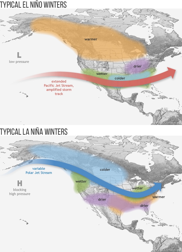
Our current El Niño began early last fall and is now expected to weaken as we head towards spring, El Niño conditions occur when warmer than normal sea-surface temperatures exist across the Equatorial Pacific. Easterly trade winds on either side of the equator become weaker during an El Niño, which is caused by a weakening pressure gradient between the eastern Pacific & western Pacific (between Peru and Australia). Weaker trade winds allow warmer surface water to surge eastward, replacing the normal cooler water off the coast of South America.Typically, during El Niño winters the Southwestern U.S is cooler & wetter than normal, and the Northwestern U.S. is warmer & drier than normal. In Jackson, historically, El Niño winters have not been our snowiest winters.
La Niña
Last winter, and the previous two winters before that, we were under La Niña conditions. La Niña conditions occur when sea-surface temperatures across the Equatorial Pacific are colder than normal. During a La Niña the Easterly trade winds are stronger, causing cooler water in the eastern Pacific to spread westward, allowing the upwelling of even colder water along off the coast of South America.Typically, during La Niña winters the Northwestern U.S. is cool & snowier than normal, and the Southwestern U.S is warmer & dry.
In Jackson, the majority of our biggest winters, like last winter’s record snowfall in the mountains, came under a La Niña. However, untypically, record snowfalls occurred throughout the Western U.S. The year before that was also a La Niña winter and Jackson had below average snowfall, as did many other areas across the West.
UCLA Study
A recent study by scientists at the University of California, Los Angeles and the California Institute of Technology, found that using ENSO to predict the winter seasonal outlook and the amount of California’s precipitation is unreliable. Their study found that ENSO only plays a minor role for total CA precipitation; instead, a majority of CA precipitation is independent of ENSO and more closely associated with the atmospheric wave patterns that develop over the North Pacific.
The study went on to say, “historical records suggest that ENSO only explains about 30-percent of the year-to-year variability of CA winter precipitation”.
Since long-range winter outlooks rely heavily on the condition of the ENSO, it might be prudent to look beyond just that particular oscillation.
Other Oscillations
Ocean circulations and water temperatures drive our weather. ENSO is just one piece of that bigger puzzle. Stronger storms tend to develop where there are bigger differences in temperature, between the North Pacific Ocean and the Equator, for instance. And also, across the North Pacific, from west to east.
While El Niño and La Niña get all the press, there are other oscillations going on in the oceans that you never hear about, which also affect the weather patterns in the Pacific and around the globe. Such as, the Pacific Decadal Oscillation (PDO), the Pacific North American Pattern (PNA), the North Atlantic Oscillation (NAO), the Arctic Oscillation (AO), the Indian Ocean Dipole (IOD), and the Madden-Julian Oscillation (MJO), to name a few.
Some of these oscillations last several years, some a few days to weeks, but they are all interacting with whatever phase ENSO happens to be in and dictating where storms develop and where they track.
I hope you can now understand that the weather we get depends on more than what is happening with ENSO. The last few winters are good examples of why you don’t want to pin the blame on just one thing. It is the complex coupling of atmospheric and oceanic circulations, and their many oscillations, that ultimately determine the weather we receive. All of that is constantly changing, which is what makes meteorology so fascinating, and challenging.
Posted by meteorologist Jim Woodmencey