A cold low pressure system brought us almost a foot of new snow in the mountains up at around 10,000-ft. in the Tetons over the last 24-hours, and this would certainly qualify as our first good snowfall of the season.
It also looks like we had about ¾ of an inch of water in the valley from this storm and over an inch of water at the higher elevations in the mountains. That should be enough to put us over the average precip for the month of October in Jackson.
 |
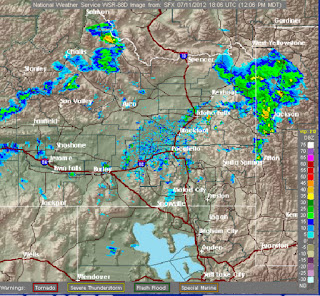
| Forecast Weather Map for Thursday Oct. 25 |
That Low pressure system is still sitting along the Pacific Northwest Coast and looks like it will keep temps cool the rest of this week and also produce some more snow as that Low sifts inland and dies out at the end of the week. (See Forecast Map for Thursday).
I’d like to say that the snow will just keep coming right through Christmas, but that scenario would be a gift, for sure, and does not seem very likely. And that is also what the Climate Prediction Center seems to think as we go into the winter months.
December – January – February Outlook
The Climate Prediction Center (a division of NOAA and the National Weather Service) is not painting a pretty picture with their latest 3-month outlook for December through February, with above normal temps for most of the Rocky Mountain West, and below normal precipitation for the Northwestern portion of the U.S.
(See maps below and keep up with all the latest short & long range outlooks on the NWS Discussions Page of mountainweather.com)
|
3-Month Outlook Maps for December- January- February 2012-2013
|
|
 |
 |
|
Temperatures
|
Precipitation
|
ENSO Update
The El Nino Southern Oscillation (ENSO), in other words, what’s happening with the sea-surface temperatures in the Equatorial Pacific, is now trending towards either Neutral Conditions (No Nino) or a weak El Nino for the winter.
I personally don’t like the “No Nino” situation, as the odds are usually against us having an above normal snowfall winter in the northern Rockies. But I would take a weak El Nino and put money on a snowier winter than 2011-12, although not as snowy as the Winter of 2010-11, both La Nina Winters.
That’s about as much as I can tell you right now, as technically I am still on my fall break and not forecasting on a daily basis. I have some weather classes I am teaching over the next couple of weeks (one in Alaska & then one in Florida, followed by one in Jackson!), plus I will be working on updates to the mountainweather.com website for the winter.
Text submitted by meteorologist Jim Woodmencey
Graphics from NOAA