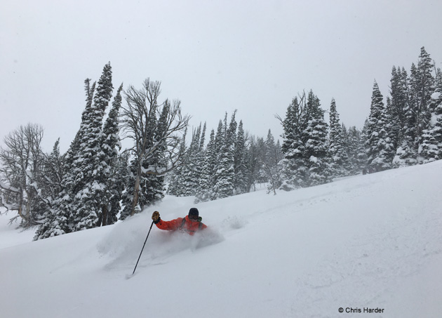
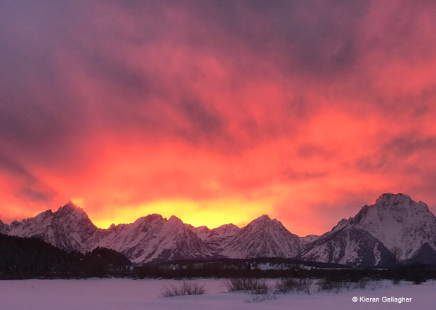
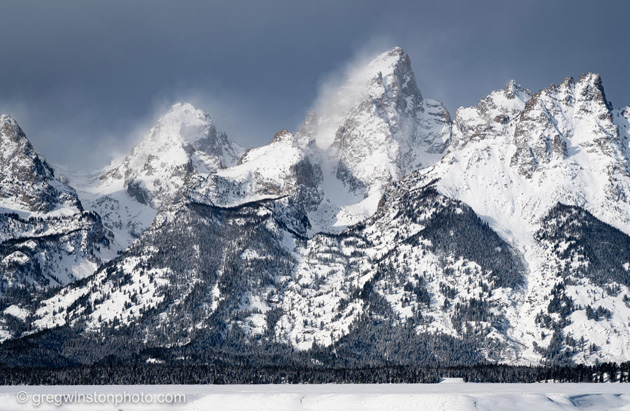
February Powder
![]()
![]()
You may not be aware of it, but today, February 5th is National Weatherpersons Day. Celebrate with your favorite meteorologist, buy him or her a beer! This is also the beginning of a steady Northwesterly flow or “Dirty Ridge” event for the northern Rockies.
As a Ridge of High pressure parks off the West Coast and a stream of moisture rides up and over the top of that Ridge, it mixes with relatively cool air from the Gulf of Alaska to make a good period of orographically enhanced snowfall.
In layperson’s terms, that means the mountains get a good dump of relatively low-density powder. Situation and snowfall accumulation forecasts below.


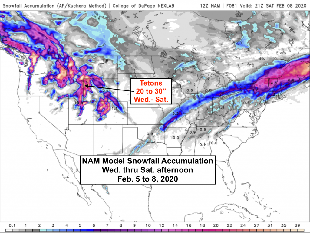
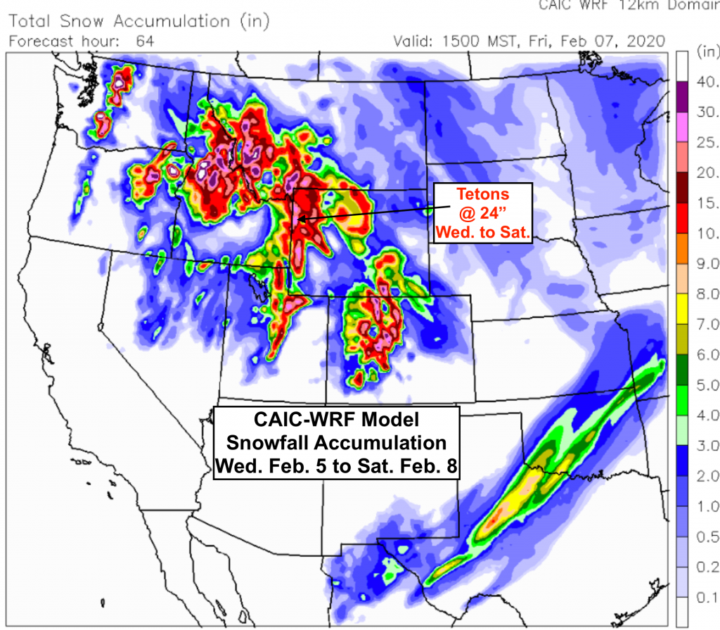
I will update this again Thursday, as a good looking little Low-pressure system moves into Washington & Oregon, bringing a West to NW flow over western Wyoming later in the weekend. That’ll keep the powder coming.
Post by meteorologist Jim Woodmencey
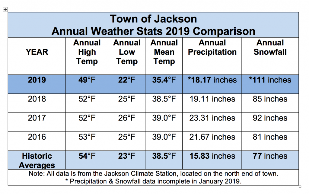
If you lived in Jackson for the last 12 months or so and I were to ask you to name three things you remember about the weather in 2019, the top three answers likely would be: 1) February was really snowy. 2) Summer was too short. 3) October was really cold.
Correct on all counts. But what you really wouldn’t know, without running all the numbers, was that 2019 was the coldest year ever recorded in Jackson, WY.
I could hardly believe it myself when I first sat down to compile the weather stats from 2019. I ran the numbers three times, I went back and dove deeper into Jackson’s weather records. I checked, double-checked and triple-checked, but there it was, 2019 ended up the undisputed champion, now holding the title as the “Coldest Year on Record”, for all of the years that we have complete weather records.
The average high temperature for the entire year in 2019 was 49-degrees. That is a full five degrees colder than the long-term historic average annual high of 54-degrees.
That made 2019 the new record holder for the coldest annual maximum temperature in Jackson. The old record was 50.4-degrees, from more than 50 years ago, in 1968.
Also of note, every month of the year in 2019 had colder than normal average high temperatures, except November, which ended up right at the long-term average.
October 2019 blew its average high temperature record off the charts, with an average high temperature for the month that was 13 degrees colder than the long-term average.
With all those cold temperatures, perhaps you had forgotten that the hottest day of the year was on July 23rd, 2019, when it reached 87-degrees.
The average low temperature for all of 2019 was 22-degrees (21.73-degrees to be exact). That is one degree colder than the long-term historic average of 23-degrees.
In 2019, there were only three months that had an above average minimum temperature, April, July and September. June and August came in right at normal for monthly low temperatures.
The coldest day of the year in 2019 was 25-degrees below zero on January 1st. Also of note was the coldest temperature ever recorded in the month of October, when it dropped to 6-degrees below zero on October 30, 2019. I’ll repeat, that is the coldest temperature ever recorded in Jackson in October.
Last year ranked as the 10th coldest year on record for annual minimum temperature. Nothing too remarkable there.
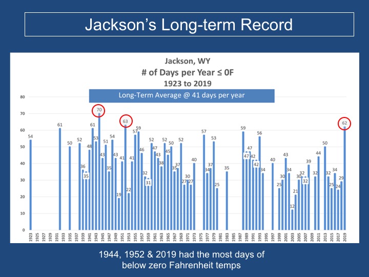
What was remarkable, was how many days of below zero temperatures Jackson experienced in 2019, 62 days. It ranked as the 3rd most days in a calendar year, in our recorded history. The last time we had that many below zero temperature readings was in 1952.
Below is a graph of the number of days each year that the minimum temperature was below zero Fahrenheit.
If you take the average of all the high temperatures and all the low temperatures for the year, you get what is called the annual mean temperature. This is perhaps the best gauge of the overall temperature for the entire year.
In 2019 the mean temperature for the year was precisely 35.36-degrees. Rounding that number up to one decimal point, to 35.4 degrees, it still beats the old record.
The old record coldest year in Jackson was 1944, which had a mean temperature of 35.5 degrees. The average high temperature that year was 51.5-degrees and the average low temperature was 19.4-degrees.
Keep in mind, to be in the competition for coldest or warmest year ever, you need 12 full months of complete weather data. There are many years, in the last 100 years, with too many missing days or months of data to even be considered as a qualifier.
It is the annual mean temperature that distinguishes 2019 as the coldest year ever recorded in Jackson.
Below is a graph of all the years which had complete records, spanning from the earliest year 1923, through the latest year 2019.
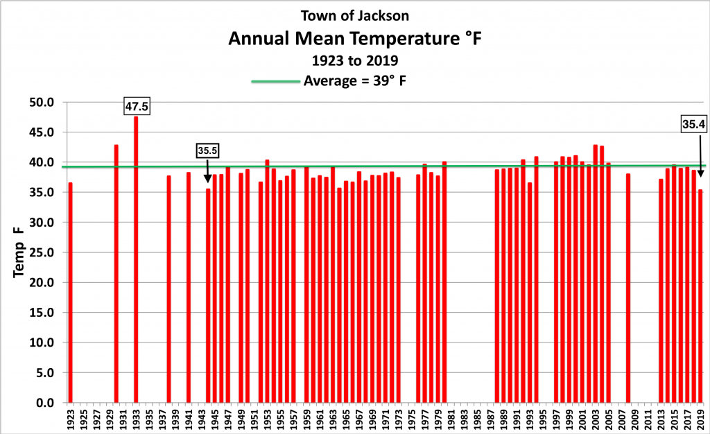
From this graph it is quite obvious that the 1990’s to early 2000’s were some of the warmest years and that the 1950’s to early 1970’s were some of the coldest. The all-time warmest annual mean temperature in Jackson’s climate record was 47.5 degrees, back in 1933.
We are now into our fourth year in-a-row that the Town of Jackson has experienced wetter than normal conditions, by an annual measure.
Jackson’s long-term average annual precipitation is 15.83 inches. In 2019, the total precipitation in town was 18.17 inches.
It should be noted that in January of 2019 there was over two weeks when precipitation and snowfall were not measured, due to the government shutdown. So, the numbers for these annual totals are a bit lower than what actually accumulated.
Fortunately, the temperature record was complete, because a number of years ago the NWS switched the climate stations over to a digital recording temperature system.
Total snowfall in the year 2019, from January through December, was 111 inches, not including the snowfall that was missed in mid-January. That is still well above the long-term average annual snowfall in town by nearly three feet! The long-term average annual snowfall in town is 77 inches.
That also makes it four years in-a-row with above normal annual snowfall in the Town of Jackson. Keep in mind, the annual snowfall number spans parts of two different winters.
February 2019 saw record breaking snowfall, with 55 inches in town. That blew away the old snowfall record for February of 33 inches, set back in 1978.
That 55 inches was also the second snowiest month ever recorded in town, falling just shy of the 56 inches that accumulated in January 1969. And February is a short month!
Jackson Hole Mountain Resort also experienced their snowiest February on record, with 149 inches. That was also their second snowiest month ever recorded, behind December of 1996, which had 225 inches.
A better way to look at snowfall numbers is to use totals from the actual winter season. Graphs of winter season snowfall are shown below, for the Town of Jackson and the Jackson Hole Mountain Resort.
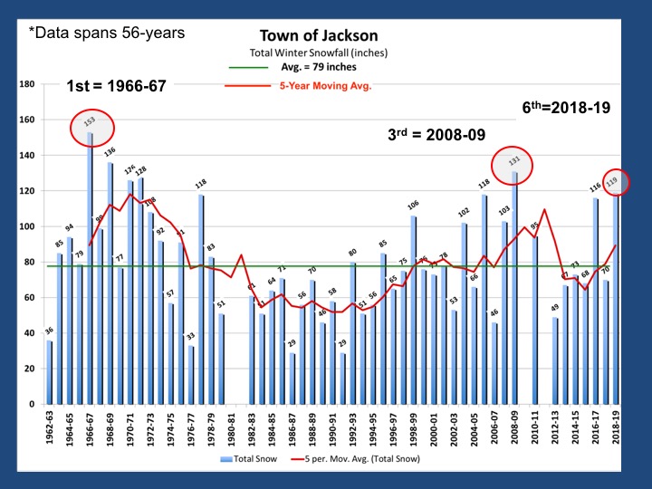
Winter 2018-19 was the 6th snowiest in Jackson’s history.
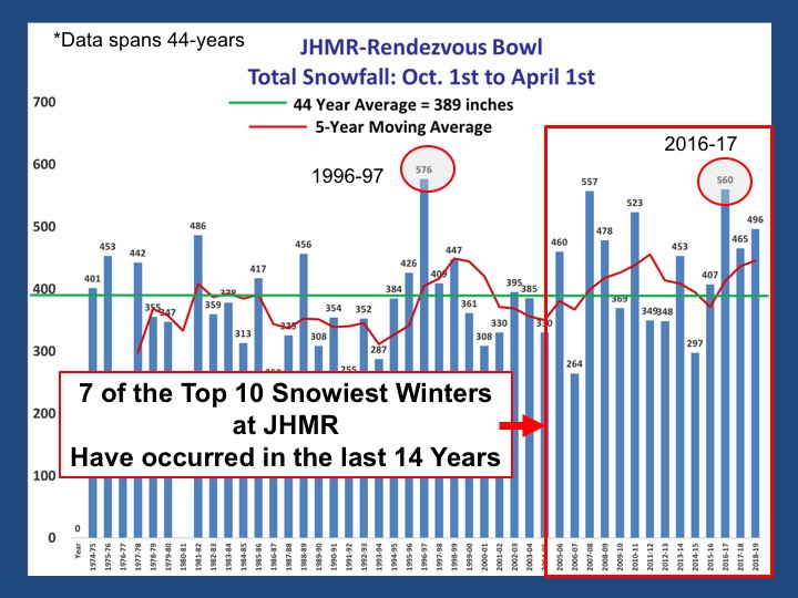
Winter 2018-19 was the 5th snowiest winter in Jackson Hole Mountain Resort’s historical records, kept since 1974-75.
It was an amazing feat to string together 12 consecutive months to crown 2019 as the coldest year ever recorded in Jackson. That, in a year which was also wetter and snowier than normal. A very memorable year, with some new records that will be hard to beat.
If you study the graphs provided, it is easy to see the recent trends in Jackson’s historic weather records. Over the last 5 to 15 years, they carry a theme of colder temperatures, more annual precipitation and more snowfall.
Post by meteorologist Jim Woodmencey
If you are a frequent Weather Channel watcher, you have probably heard the terms they use to describe a variety of winter storms, such as, “Atmospheric Rivers”, “Polar Vortexes” and “Bomb Cyclones”. All of which sound quite ominous! It reminds me of that line in the Wizard of Oz, “Lions and Tigers and Bears, Oh My!”
From my perspective, these terms are used to create a state of panic, to get you to stay tuned-in. It’s what some meteorologists refer to as, the “atmosfear”. If you can make it sound like some sort of weather Armageddon is coming, then perhaps more people will keep watching.
In this week’s column, I’ll explain some of these fearsome terms you might hear about this winter and perhaps calm some of your fears.
An “Atmospheric River” is simply a continuous feed of moisture, for example, from the eastern Pacific into the western United States. Generally, that moisture is carried along in a strong jet stream flow. If that river of moisture lines up over you, expect several days in a row of continuous precipitation, in the form of rain or snow, depending on temperatures.

Another term you may have heard in the past is, “Pineapple Express”. That doesn’t sound too bad, could be a name for a tropical drink you might order in a bar. The pineapple express is also an atmospheric river.
Atmospheric river sounds much more threatening, thus the recent switch in terminology used in the media.
The “Polar Vortex” is more often an eastern United States phenomenon. All it is really, is a deep, cold trough of low-pressure in the atmosphere, which brings very cold air much further south than normal. But that’s too many words and doesn’t sound nearly as sexy as just saying, “Polar Vortex”.

Cold air that originates up near the north pole, is the polar part. The low-pressure is the vortex part of the name. All low-pressure systems or storm systems are vortexes. That is, any cyclonically rotating (counterclockwise) area of lower pressure in the Northern Hemisphere is a vortex. Again, that isn’t a very catchy way to describe it.
If you wanted to, you could call it a “Polar Cyclone” and make it sound even scarier.
Cyclone is yet another term used to describe a low-pressure system or any storm. The term “Bomb Cyclone” refers to a center of low-pressure that has a precipitous drop in its central pressure in a short time. The criteria for calling it a bomb is, 24 millibars of pressure decrease in less than 24 hours. An average drop in pressure for a developing storm is about half that rate.

A bomb cyclone, or “bombogenesis”, as it is also known in meteorology, is simply a rapidly intensifying low-pressure system. They usually form along either the Northwest or Northeast Coasts of the United States. A bomb cyclone hit the Oregon Coast this past Thanksgiving.
Don’t be Scared
All of these three terms I just described have been around and known to meteorologists since about the 1950’s. Media outlets, like The Weather Channel, love to use them to help sensationalize the weather. Having catchy monikers helps reel you in.
The Weather Channel has also adopted the practice of naming winter storms, in the same manner the National Weather Service names hurricanes during the summer. The NWS does not give official names to winter storms, by the way.
Often times, all it amounts to is just another a winter storm, like many winter storms that we get in Wyoming, or anywhere else in the country for that matter.
Don’t be afraid, it’s just the weather, doing what weather does. There is nothing new or more severe about it just because it has been given a sexy name.
The National Weather Service issues watches and warnings, those are what you should pay attention to this winter season. They will let you know when the potential exists for severe weather that might hamper travel. Those are the days when it is best to just stay home and hunker down by the fire instead of heading outside where there might be lions and tiger and bears, oh my!
Post by metetorlogist Jim Woodmencey
This article originally appeared in the Jackson Hole News & Guide on December 31, 2019.
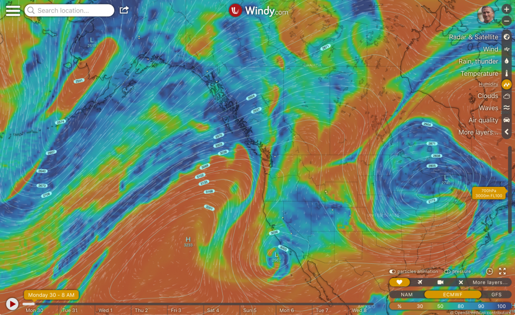
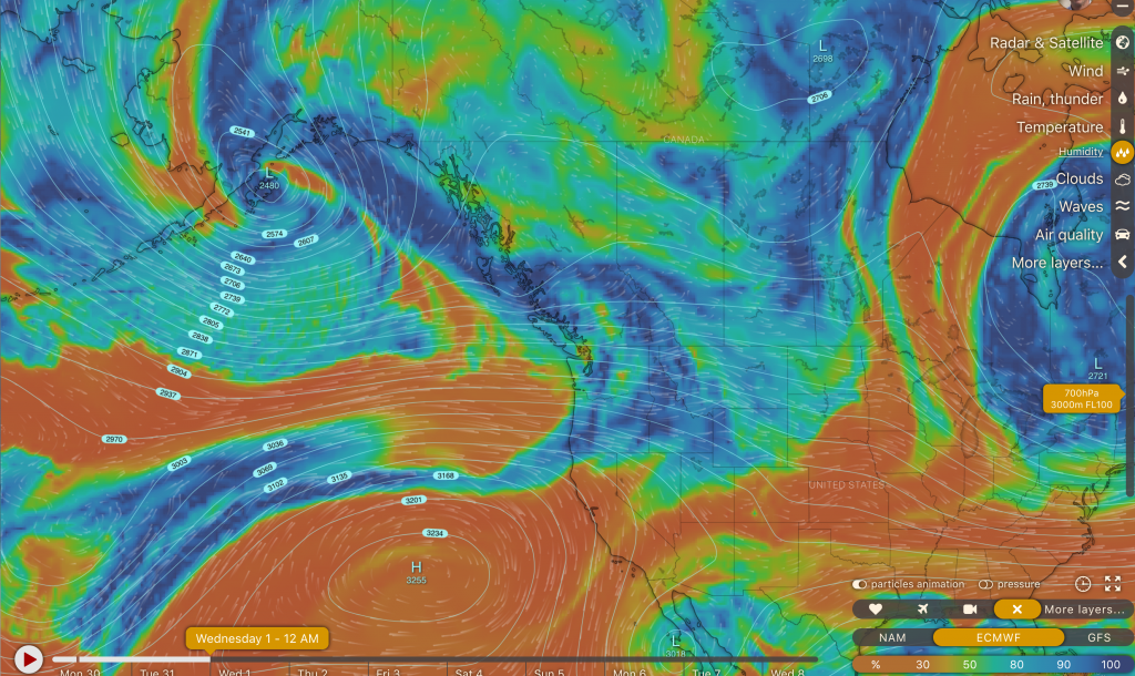
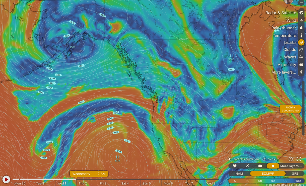
Low-pressure systems have been swinging across the Southwestern U.S. this past week or so, but leaving the northern & central Rockies to catch the fringes of those weather systems. That is about to change, for the start of the New Year.
This series of 700mb maps (@10,000-ft.) shows the transition of the weather pattern over the next few days, A dry & cold Northerly flow over the northern Rockies today, December 30th, gives way to more of a Westerly flow aloft Tuesday and then a Northwesterly flow New Year’s Day. The blue shows areas of moist air and the orange is dry air.
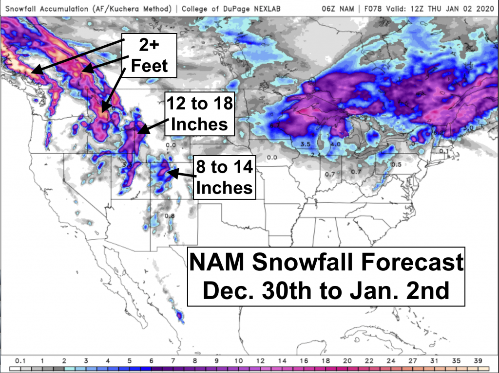
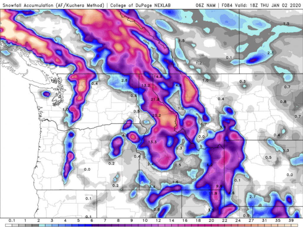
Here are two short-term snowfall forecasts for Dec. 30th to Jan. 2nd.
The NAM Model (North American Mesoscale) is first. The WRF Model (Weather Research & Forecasting) is next from the CAIC (Colorado Avalanche Info Center).
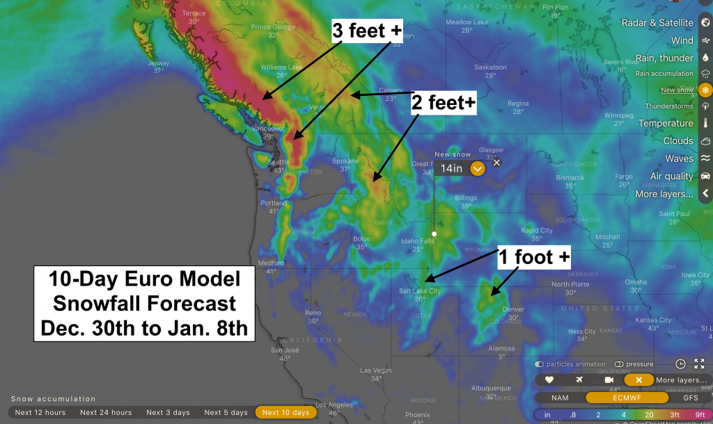
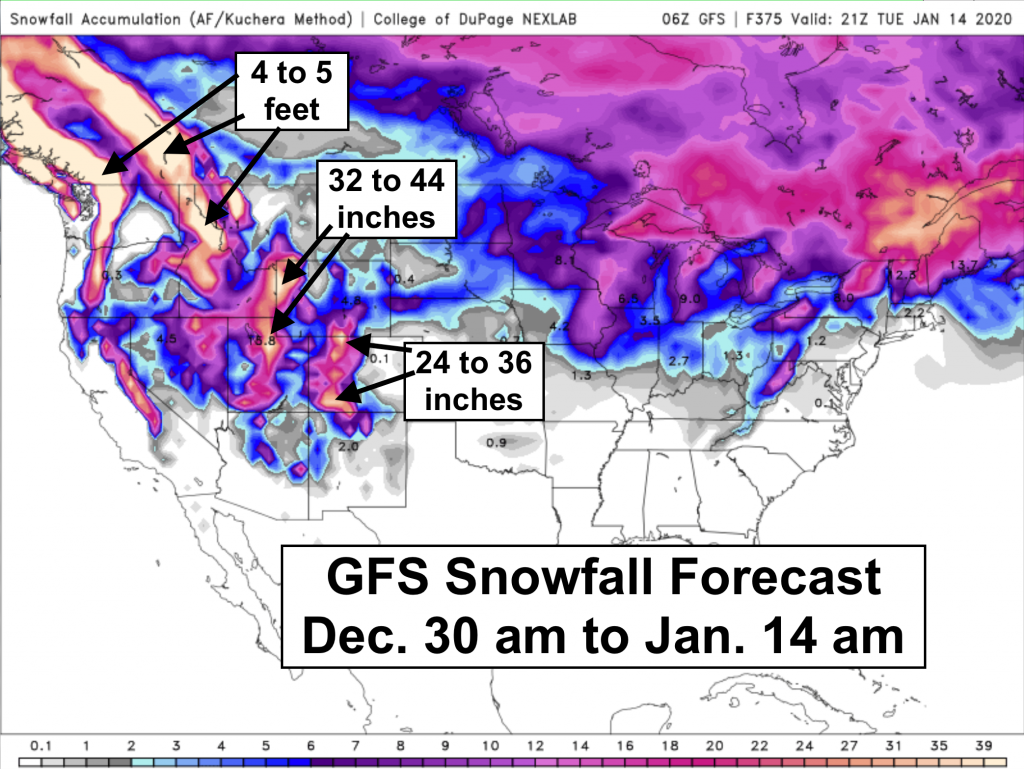
Next are two model forecast that take us out 10 to 14 days, respectively. The European Model is the weakest for snow accumulation over the next 10 days (Dec. 30 to Jan. 8). The GFS (Global Forecast System) goes pretty big with snow accumulation for the next two weeks in the Rockiess, between Dec. 30 and January 14th, 2020. Good news for the start of the New Year, if it all comes true!
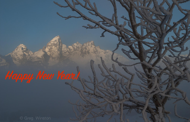
Happy New Year Everyone!
Post by meteorologist Jim Woodmencey
The outlook for fresh powder in the Western United States between Christmas and New Year’s Day is not looking too cheery for many locations.
A split jet stream flow in the Pacific will send three separate Low pressure systems on a southerly track across the Southwestern U.S. That will favor the southern Sierra Nevada (Mammoth) and the San Juan Mountains (Telluride) for snowfall.
In the northern Gulf of Alaska, more of a West to Sw flow wil bring plentiful moisture & the biggest snow accumulations across British Columbia, Canada’s mountains.
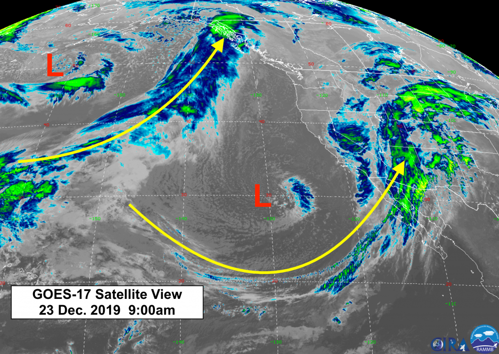
Current Satellite map Monday morning Dec. 23rd, 2019:
Short-term and longer term forecasts below for total snow accumulations.
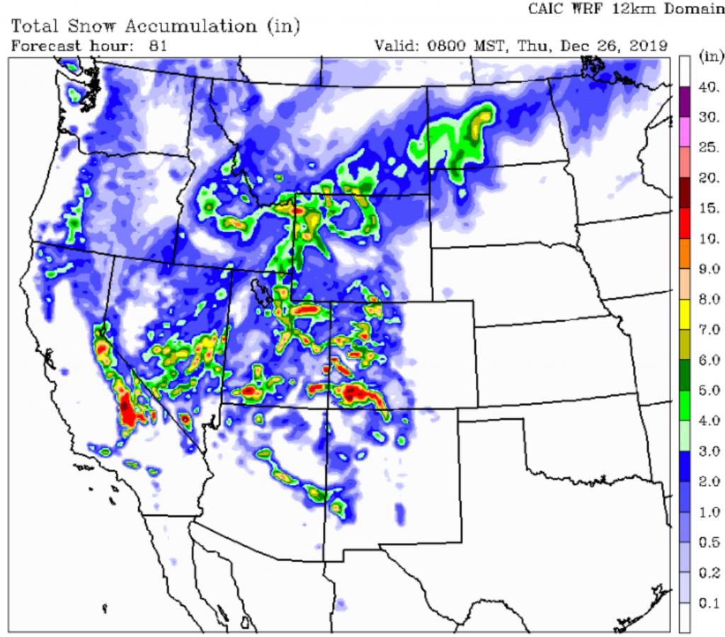
First up is from The Colorado Avalanche Information Center’s WRF model, with snow accumulations through Christmas Night. Looks like theirs is the most optimistic, with 4 to 7 inches for the Teton Mountains & about 3 to 4 inches for the Jackson Hole Valley.
A little more for the Wasatch Mountains & Yellowstone Park. The Uinta Mountains of Utah, Southern Sierra & San Juan Mountains of Colorado look to get the most, with a foot or more.
Looking just beyond New Year’s Day, the 10-day snowfall forecast from the European model shows only a little more snow most places in the West. British Columbia scores the most snow.
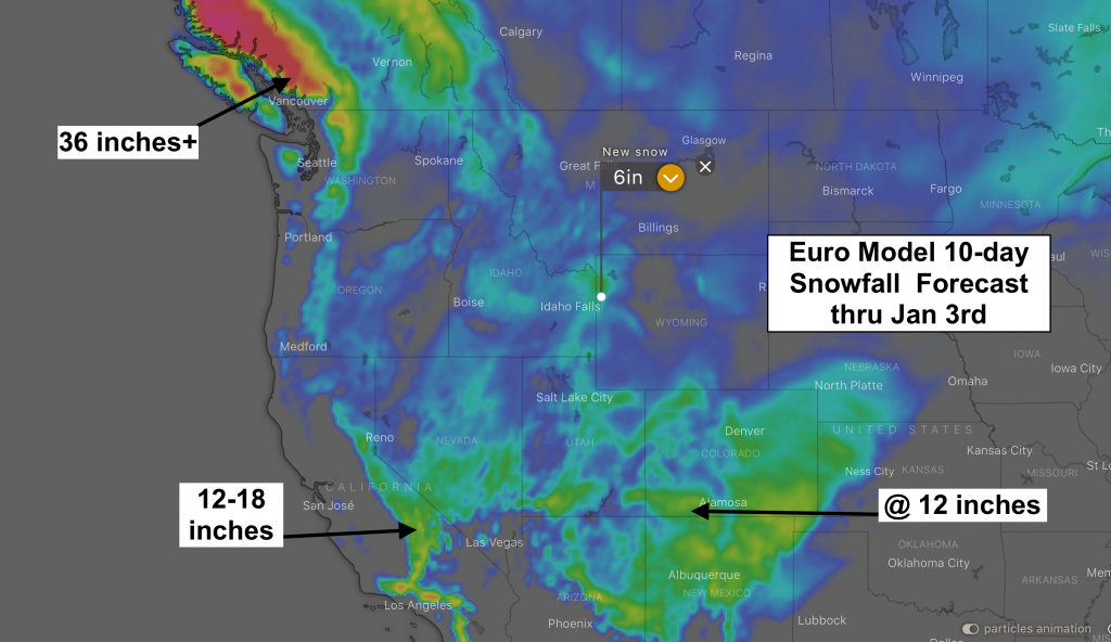
The weather patter looks like it finally changes to something more favorable for the northern Rockies by the end of the first week in January 2020.
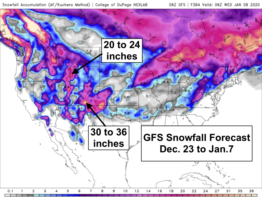
Below is the GFS model snowfall accumulation forecast for Dec. 23, 2019 to Jan. 7, 2020. The bulk of that snowfall for the Tetons comes between January 5th & 7th.
Merry Christmas & Happy New Year!
Post by meteorologist Jim Woodmencey