As the old saying goes, “If March comes in like a Lion, it will go out like a Lamb”, and vice-versa. In other words, if the weather is winter-like and stormy to start the month, it will end with milder, more spring-like weather. Or, the opposite could be true, if it comes in like spring it will go out like winter.
This year it looks like the lamb will show up on Saturday and then be immediately devoured by the lion on Sunday across the Northern Rockies and at home here in Jackson Hole.
Saturday we should see temperatures in the Jackson Hole Valley topping 40 degrees in the afternoon, and temperatures at 10,000-ft getting up into the lower 30’s, with plenty of sunshine to give us a little taste of Spring. Then clouds increase Saturday night and a storm system that rolls across Montana will bring snow and colder temperatures to Northwest Wyoming on Sunday.
Northwest Wyoming’s Teton Mountains should accumulate 6 to 9 inches Saturday night thru Sunday night. Northwest Montana & higher elevations in the Cascades of Washington might get a foot or so Saturday thru Sunday. And the Southern Canadian Rockies might score the biggest, topping two feet, but that includes snow from Friday and all day Saturday, as well as Sunday’s snowfall. (See Snowfall Forecast Maps below for this weekend).
|
Snowfall Forecast Maps Saturday thru Sunday March 2nd & 3rd
|
|
|
|
|
Northwest USA
|
Zoom on Wyoming & Utah
|
The Rest of March 2013
How the month ends weather-wise is no more conceivable than how it started……do we call it Lion or Lamb-like?
Not much change is indicated in the longer range computer models for March, and a “neutral” or No-Nino condition in the Equatorial Pacific that began in January is expected to last through our Northern Hemisphere Spring.
What is interesting about this March is that temperatures are expected to be below normal. Surprising, because the trend over the last couple of decades has been that temperatures in the month of March in the Rockies have been climbing. Oddly, March is the one month of the year that the statistics in Jackson at least have been consistent and indicating the most warming in the long-term climate trend the last 50 years. So, maybe we are starting a trend to even that out a little.
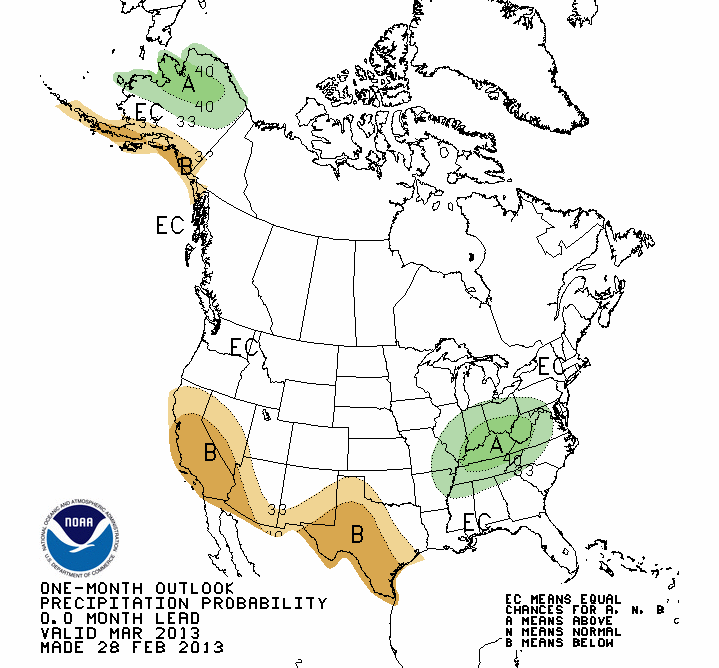
Precipitation Outlooks in March still indicate “equal chances of being above, below, or at normal” for the monthly precipitation (and snowfall) this March, across the Pacific Northwest and Northern Rockies.
You might interpret that to mean that there would also be equal chances of March going out like a Lion or a Lamb. A wooly one at least, since temperatures are supposed to be below normal.
(See the 30-Day Outlook Maps below).
|
30-Day Outlook Maps for March 2013
|
|
|
|
|
Temperatures
|
Precipitation
|
Post by meteorologist Jim Woodmencey
Graphics from and NWS