
Fall at Oxbow Bend
![]()
![]()


This article first appeared in the Jackson Hole News & Guide on Sept. 11, 2019
I get it all the time, starting in late August, when I am the grocery store, out hiking on the trail, from people passing in the opposite direction while on my mountain bike. I can’t seem to go anywhere this time of year without being asked, “What kind of winter are we going to have?”
I realize it wouldn’t look good professionally if I simply replied, “I don’t know”. But to be honest, I really don’t know. Mainly because I haven’t been thinking about snow, especially when it was still 80-degrees and sunny outside.
With all that asking, I decided I better sit down and see what the long-range outlooks are saying. So, for this week’s column, I’ll provide you with three individual outlooks for Winter 2019-20 for the Rocky Mountain region. And also review what they said about last winter’s weather (2018-19), so you may gauge their accuracy.
There are two main weather Almanacs available, both with a long history of weather prognostications, the Farmers’ Almanac and the Old Farmer’s Almanac.
The Farmers’ Almanac is calling for “Frigid and Snowy” for all of Montana, Wyoming and Colorado this coming winter. That sounds good for us. Utah comes under the heading of, “Cool, and Normal Precipitation”.
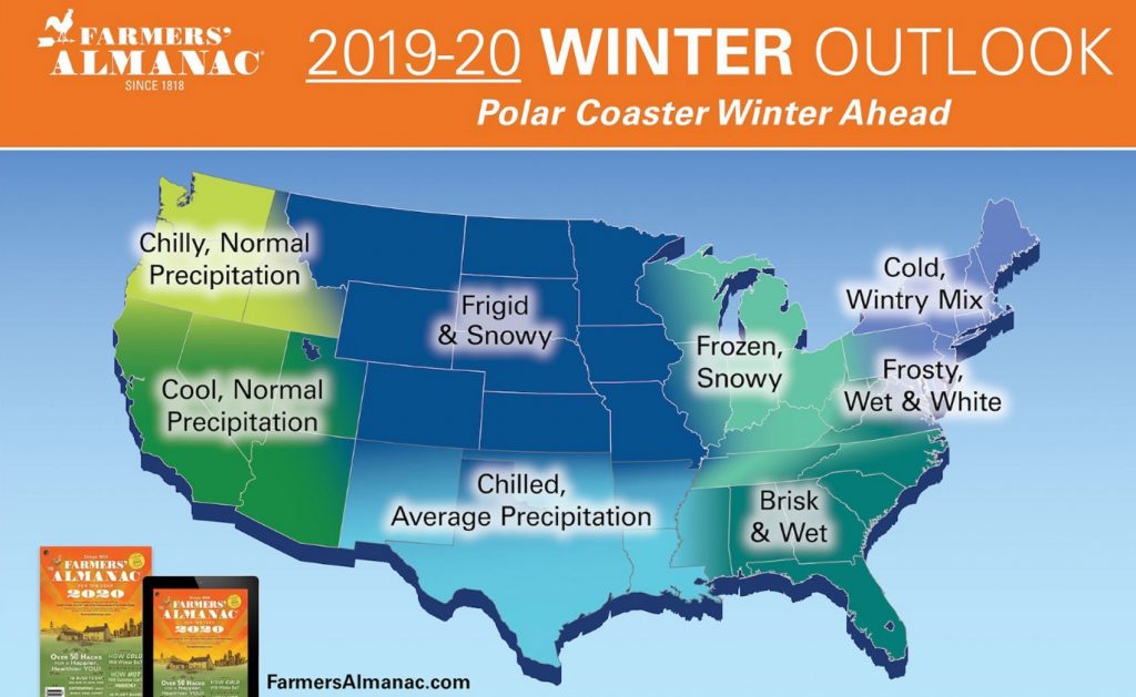
Last winter, The Farmers’ Almanac’s forecast for Wyoming was, “Teeth-chattering cold and Snowy”. Fact is, it actually was much colder than normal in Jackson last winter, along with above average snowfall, mainly due to the record snowfall we had in February 2019.
The Old Farmer’s Almanac’s outlook for this coming winter says exactly what you would want to hear if you are a winter sports enthusiast, “Low Temps, Deep Powder”. That forecast is valid for southern and central Idaho, most of western Wyoming and Colorado, as well as, all of Nevada and Utah.
The Old Farmer’s also has northern Wyoming and all of Montana under a forecast that says simply, “A Parade of Snowstorms”. Seems like a can’t-miss situation for Jackson Hole!

How did the Old Farmer’s Almanac do with last winter’s prediction for our area? Their forecast for Winter 2018-19 was, “Mild and Snowy”. OK, so they missed on the temperatures, but nailed it by saying “Snowy”.
I could pretty much cut and paste the forecast from last winter from the Climate Prediction Center (CPC), a division of NOAA, and plug it in here for this coming winter.
The CPC’s latest prediction for December 2019 through February 2020, issued on August 15th of this year, calls for a 55-percent chance of warmer than normal temperatures over western Wyoming. Bucking the cold trend the two almanacs are predicting.
The CPC also has western Wyoming under what they call “Equal Chances” for above normal or below normal precipitation for Winter 2019-20. Not nearly as encouraging as the two Farmers forecasts.
If you are keeping score, the CPC was wrong about temperatures last winter, it was not warmer than normal, it was much colder than normal. Their prediction on precipitation was also non-committal last year, “Equal Chances”.
Come on CPC! Stick your neck out and go one way or the other. Call it “above” or “below” normal precip, you still end up with a 50-percent chance of being right!


One of the final indicators of winter weather is the ENSO forecast, the El Nino Southern Oscillation. Last winter we were in a weak El Nino and were not supposed to be cold or snowy. Based on that predictor, we should have seen warm and dry conditions in the northern Rockies. It was quite the opposite.
This winter, the “consensus” among NOAA’s ENSO forecasters is that the current “Neutral” conditions in the Equatorial Pacific, which began in July, will continue through the Northern Hemisphere Winter 2019-20.
What does that mean for us? Absolutely nothing. Why do I say that? Because, we have had above normal snowfall in the mountains for the last 5 out of 6 winters, while under El Nino, La Nina, and No Nino (Neutral) conditions. Therefore, at this point I have to discount the ENSO as an indicator.
There you have it, that’s everything I know about how this winter might shape up. So, the next time someone asks, “What’s kind of winter are we going to have?”, I can simply answer, “Haven’t you read my column in the Jackson Hole News and Guide?”
Jim is the chief meteorologist at mountainweather.com and has provided a weather forecast for Jackson Hole and the Teton Range for over 25 years.

With the weather starting to change from summer-like to fall-like this past weekend, and more cold storms rolling across the Western U.S. this week, I thought it might be a good time to remind people to be more weather-vigilant when planing excursions into the mountains.
Whenever I see that first cold weather system approaching on the weather maps and then that first bit of new snow high in the Tetons, I am reminded of September 1985.

Back then, I was working in Grand Teton National Park as a Climbing Ranger, when the call came in that multiple parties were overdue from their climbs of the Grand Teton the day before.
It was late morning on Thursday, September 12th, 1985 and still pouring rain in the valley and snowing hard above the 8,000-foot elevation in the mountains. I cringed at the thought of having to hike up Garnet Canyon in that kind of weather.
Fellow ranger Renny Jackson and I loaded our packs, steeling ourselves for full-on winter conditions, and headed up the trail. Just above the snowline, near the Platforms camp at around 9,000-feet, we switched to our winter mountaineering double-boots.
By the time we hit the Middle Teton Glacier moraine at just over 10,000-feet, we were plowing through snowdrifts that were two to three feet deep, and punching down to the rocks beneath the snow.
When we reached the Lower Saddle at 11,600-feet, we experienced winds that were hurricane force, in excess of 75 mph. On our approach to the start of the Exum Ridge, we were forced to the leeward side of the Saddle, to avoid being blown over, and several times we had to drop to our knees in a crawl. Visibility was horrible, as well, in the sideways driving snow.
Our shouts into this maelstrom probably traveled no further than a foot or two from our lips, in a futile attempt to make verbal contact with anyone that might still be alive on the mountain. It was getting dark, and we felt going higher would be futile, so we returned to the Saddle to wait for morning, and hopefully better weather.

The weather the previous day, Wednesday, September 11th dawned clear and temperatures were relatively warm. The storm began early that afternoon, catching several parties high on the Exum Ridge. One party, more familiar with the mountain, managed a quick escape from the wind and snow that quickly enveloped the mountain.
Two other parties, a party of three and a party of two, who were unfamiliar with their route, would spend the next two days trying to find their way down from near the summit of the Grand.
During the next two days, it snowed continuously and the wind on the mountain was incessant. Not the kind of weather you would want to be caught in for more than an hour, dressed in light summer mountain apparel, as these five individuals were. Let alone sit out two nights at 13,000-feet without any shelter.
Unfortunately, two of the five young men, would succumb to hypothermia. A third would slip on the icy rocks and plummet to his death over a cliff.
After our failed attempt to get higher on the mountain during the height of the storm, Renny and I would be welcoming additional help from Rangers Leo Larson and Randy Harrington, who were hiking up in the dark to join us.
During a brief break in the clouds, well after nightfall, as Randy and Leo approached the Lower Saddle hut, I was standing outside looking up towards the mountain and thought I saw the light of a headlamp, high in the gully to the west of the Exum Ridge.
Leo, Randy, and Renny confirmed that I was wasn’t seeing things. Then it was game-on, as the four of us re-packed and headed back up the mountain that night with newly inspired energy, which came from knowing someone was still alive.
It was cold, it was dark, the wind made it miserable, and the mountain was completely iced over. But we were well equipped for the task ahead. As Renny put it, “It was more a discounting of personal comfort than it was personal safety”, for us.

For the two remaining survivors, we arrived at their location just in time, and spent the rest of the night trying to re-warm them, as best we could. Overnight, on what was now Friday, September 13th, the temperatures on the mountain dropped down to near 20-degrees, with the wind-chill factor it would feel like it was well below zero. In plastic double-boots that was tolerable. In summer hiking shoes, like the two remaining climbers had, their feet were like blocks of wood, from frostbite.
Whenever we have that same type of weather in September, I am reminded of that storm in 1985. I always look up at the mountains and hope no one is caught up there, unprepared.
In a way, it was that September storm that has driven me in my career as a meteorologist, to always try and get the forecast right. As if someone’s life might depend on it.
Jim is the chief meteorologist at mountainweather.com and has been forecasting the weather in the mountains for over 25 years.
Note: This story was chronicled in Sports Illustrated, December 15, 1986 issue and the full tale can be read on-line in the SI Vault, link below:
Forecast Thursday, August 29th, 2019:
The Western U.S. looks to stay generally dry & warm through Labor Day. Some showers or thunderstorms possible Thursday night & Friday in the Rockies (UT-CO-WY-MT), just before the kick-off to the weekend.
Saturday through Monday look good, except for some afternoon build-up & isolated thundershowers developing over parts of the Northern Rockies in Montana & Wyoming.
Click Map Below for Clouds (gray) & Precip (blue) through Labor Day.

In the Pacific Northwest, Seattle and the Cascades will see some rain as a Low-pressure system in the Gulf of Alaska moves closer to the Coast of Washington & British Columbia.
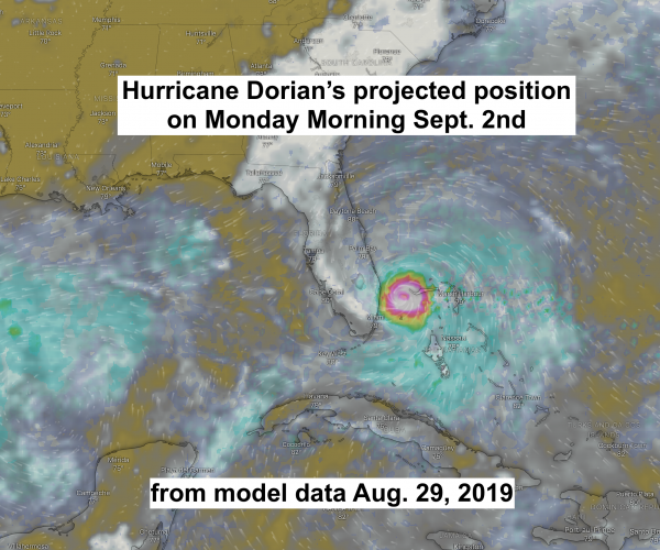
Hurricane Dorian
All eyes are now on the Bahamas and Florida this weekend as Hurricane Dorian moves across the Caribbean.
Click Map Below to play video of Dorian’s projected movement
Post by meteorologist Jim Woodmencey


From fishing, boating, hiking and climbing, to softball, soccer and golf, summertime activities can frequently expose us to the dangers of lightning.
Knowing the dangers and what to do if caught outdoors in a thunderstorm, may help you avoid being zapped this summer. So, as I do every year, I’ll review some lightning safety tips for you in this week’s column.
Electrical Casualty
Your standard household electrical outlet carries 120 volts of electricity. A single lightning bolt can generate up to 100 million volts of electricity, for a micro-second.
The temperature of a lightning bolt, during that split second, can reach 54,000-degrees Fahrenheit, which is about five times hotter than the temperature on the sun.
The electrical energy and intense heat from lightning can hurt you in a number of different ways:
1) Direct Strike. This rarely happens, however, if you were unlucky enough to take a direct hit, it would be game-over, right then and there.
2) Conduction. Electrical energy travels through all metal objects, but also through graphite, carbon-fiber and water. During electrical storms avoid direct contact with wire or chain-link fences, your fishing pole, hiking poles, bicycle or boat. Think of sticking your finger in a light socket, multiplied by about one-million times.
3) Side-flash. The heat & electrical current that emanates outward through the air from a nearby lightning strike can cause cardiac arrest, concussive injuries, severe burns and/or nerve damage.
4) Ground Currents. When lightning strikes the ground, the electrical current is carried outward, radially, in all directions through the ground. If that current reaches you, where you are standing or sitting, it can travel through your body. Cardiac arrest, burns and nerve damage are all possible from ground current.

Direct hits and conduction account for about 20-percent of all lightning casualties. Side-flash accounts for about 30-percent. Ground currents are the most common way people are injured or killed by lightning, accounting for 50-percent of the casualties.
Safest Retreats from Lightning
The safest place to be during a thunderstorm is in a building or a car. A “building” means a 4-walled structure with a foundation and grounded electrical and plumbing. A picnic shelter or large tent may keep you out of the rain, but your lightning exposure is the same as standing out in the open.
It is not the tires on your car that insulate you, it is actually the metal frame and body of the car that dissipate the electrical energy around you. A motorcycle or bicycle do not offer this same “halo” of protection.
If there is not a building or car to retreat to, get to lower ground. Get off ridgetops, off the water, if you can, get to a grove of similar height trees to wait it out. Do not run for the biggest, lone tree to get out of the rain.
There is not much we can do to protect ourselves from a direct hit. Conduction is something we can protect ourselves from, by not being in contact with any objects that can conduct electricity, including water.
By the way, even other people can conduct electricity, like when standing in a crowd.
Don’t Huddle-up
Lightning that strikes nearby will generate intense heat and electricity, possibly resulting in side-flash injuries.
Think of a lightning bolt like a hand grenade. The standard U.S. Army grenade has a kill radius of around 25 feet and a casualty (injury) radius of roughly 50-feet. A group of people, standing close together, will result in more casualties.
When lightning is present, don’t huddle together. Instead, spread out 25 to 50 feet apart. That way, if someone does go down after the explosion, others in the group can give aid.
Feet Together
While ground current kills or injures the most people every year, it is perhaps the easiest to protect ourselves from. If you find yourself outside with no good place to hide when lightning is striking nearby, then just stand still with both feet together.
The current that travels through the ground will take the path of least resistance and can go up one leg, through your body and exit out the other leg. Keeping your feet together at all times can prevent that current from getting to your vital organs.

Final Review
If you can’t, “Get indoors when thunder roars”, as the National Weather Service slogan says, then:
1) Get to the best un-exposed location you can.
2) Get away from any metal objects you are carrying.
3) Spread your group at least 25 feet apart.
4) Stand with both feet together, and wait it out.
My hope is, by following this advice, you will have a safe and un-shocking summer.
This post appeared originally in the Jackson Hole News & Guide